
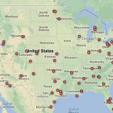

We ran across an interesting map put together by the Electronic Frontier Foundation that displays locations where the FAA has issued permits authorizing the use of unmanned aerial vehicles, or drones in the United States. Here is a link to an interactive version of the map with more information.
Below we have pasted some information from the map with a few details about land management agencies that have had these permits. Two of them have expired, and two are still active.
****
Governmental Body/Entity: California Fire Services
Type of Drone: Insight A-20
Status: Expired
General Location of Drone Activity: Shasta, California
Stated objective/purpose of COA: To deploy the Insight A-20 in support of wildland fire defense in California for the 2008 fire season. The Insight A-20 utilizes the Insight Unmanned Aerial Vehicle (UAV) with transponder and radar directional control from a command vehicle using certified pilots and a fail-safe control to either land or return the vehicle to home base in the case of loss of communications.
Effective Dates: July 3, 2008 – August 3, 2008
======
Governmental Body/Entity: U.S. Forest Service
Type of Drone: Raven (RQ – 11A, RQ – 11B)
Status: Expired
General Location of Drone Activity: Missoula, MT
Stated objective/purpose of COA: Operational readiness testing for upcoming R & D tests related to Wildland fire fighting. General flights will be no more than one half mile from ground control station at around 500 feet AGL.
Effective Dates: March 13, 2008 – ?
Comments: R&D Testing for drones to fight wildfires; There appears to be approval of guidance for operations of unmanned vehicles in a memo dated 3/13/08
======
Governmental Body/Entity: Dept. of Interior-National Business Center/Aviation Management
Type of Drone: Unknown
Status: Active
General Location of Drone Activity: Boise, ID
Stated objective/purpose of COA:
Effective Dates:
Comments: Still waiting for records
======
Governmental Body/Entity: U.S. Dept of Agriculture
Type of Drone: BAT 3 UAS
Status: Active
General Location of Drone Activity: Tombstone, AZ
Stated objective/purpose of COA: The objective of this project is to acquire digital imagery from the UAS for rangeland vegetation mapping, rangeland inventory assessment and monitoring. The UAS is capable of flying at elevations that allow for mapping of vegetation and soil patterns not feasible with piloted aircraft. The project is a collaboration between USDA Agricultural Research Service (ARS) Jornada Experimental Range and the USDA ARS Walnut Gulch Experimental Watershed and Southwest Watershed Research Center. Operation of the BAT 3 UAS at 700 ft AGL for the purpose of image acquisition. The UAS will be launched/recovered from a remote field location approx. 7 miles NE of Tombstone, AZ. The flight area will be flown 3 times over a period of 3 days.
Effective Dates: 2008-2011
Comments: USDA has COAs covering 2008-2011 for various parts of the country and various types of drones. The most recent one is missing.
You are right, Jerome
By the time the dreamin gets done about UAV’s and their saving graces come and say that it saves money……
I would venture to say tanking a drone would cost nearly as much as an 10 yr old C130 after R&D cost and manufacture…..
Yes…. focus people focus….it will take at least 5 more years and cost 5X as much to build a “tanked drone.”
Get it? “Tanked”
Hell, there are enough CBP drones out there that the LMA’s could share costs with other folks already in the drone businress…….but NOOOOO we “gots” to have our own so we can be relevant as others in the business.
No wonder we are in the shape we are in…..tanker studies, lack of clarity on wildfire suppression and RX burning, lack of clarity in policy to make more policy…but we NEED a drone for our own!!!
Tanking a drone? Done…
http://www.nitrofirex.com/
Is this what we wish for and need?
To start, How about we focus on purpose built large air Tanker with a good Tank system that will fight fires for the next decades!
There’s a need for it, allover the world!
Until this air tanker fisaco is sortied out why don’t we “tank” a drone? Ten gallons is better than no gallons. Just maybe the fifteen minute (not hours)
policy of quick initial attack would work. Unless the weather in the Western States turns around in the next thirty days (yes thirty days, the weather clock is ticking) last years fire season will look mild compared to what is ahead.
I would have to agree with Jerome on this. From my experience from working at a tanker base I know for a fact that Air Attacks, Leads, Tankers, Copters usually show up few minutes after the call and sometimes before any engine can reach the scene.
B. Morgan;
I disagree Air Attacks, Leads, Tankers, Copters usually show up few minutes after the call and sometimes before any engine can reach the scene.
During IA, the situation is usually simple enough to understand. later on it can become more complex and poor visibility can make air ops complicated.
Put Flir/mapping/downlink data on Air Attack ships … would be my choice instead of Drones.
Jerome
Some of the smaller drones have value during the initial attack period prior to the arrivial of aviation resources. These can be be easy to launch by a couple of people and give instant feed back to the IC on a laptop. Larger drones would give more airtime and some advanced information with the right sensors. I’m sure they are out there that can be launched from a dirt field or country road.
Are there any camera/instrument units that can be attached to a helicopter quickly to give picture and data back to a ICP?