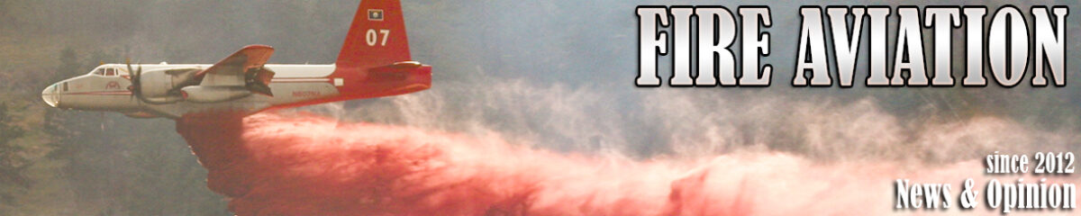
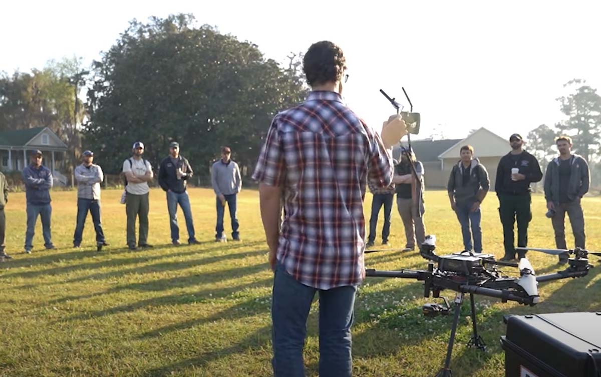
News 13 out of Asheville recently got up close and personal with a piece of firefighting technology when a news crew joined a North Carolina Forest Service drone pilot on a grid mission to map hotspots. Firefighters are tracking daily progress in heat reduction across the 434-acre Poplar Drive Fire. It is now about 45 percent contained.
“We can give the guys in the field a list or a map; we have tablets that we put the dots on and they can walk right to the dot and see it’s a stump hole or something and they can put water on it,” said Matthew Bishop, a drone pilot based out of New Bern. He explained that the drone flies overnight and shoots infrared photos that feed to a computer program that produces location data.
“We used to call it gridding by hand, and you would literally use the back of your hand,” Bishop said. “This makes it a little easier on everybody.”
Firefighters drowning hotspots on the fire in North Carolina
The grid mission was mapping the area where Green Mountain Road meets Kyles Creek Road. Bishop said there could be thousands of hotspots the drone sees that may not be visible to firefighters on the ground, but they can check them the next morning. “We all can see smoke with the helicopters or the regular camera,” said Bishop, “but it’s hard detecting the heat without the thermal imagery.”
Drones can fly in most weather and are water-resistant; they’re equipped with a wide-angle camera, a camera with 200x zoom, and a thermal imaging camera, along with a laser rangefinder to pinpoint precise locations.
News 13 also reported that temporary flight restrictions (TFRs) were established over the fire to keep the public from interfering with firefighting operations.
“On this fire, we’ve got one helicopter that’s providing drops,” North Carolina Forest Service Public Information Officer Philip Jackson said. “We have a scout plane looking for hotspots. If there’s other drones in the area, it might make us ground our own pilots for safety concerns.” Persons violating the TFR are subject to hundreds of dollars in fines.
The TFR up to 7,500 feet was established by state forest officials last Wednesday.
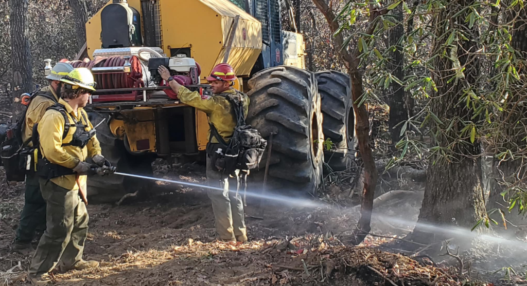
Two state burn bans in 30 western North Carolina counties: Last week, because of increased fire risk, the N.C. Forest Service issued a ban on all open burning and also canceled previous burning permits for many counties until further notice.
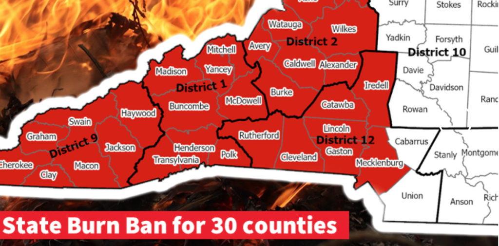
A dozer cutting line on the Poplar Drive Fire
“With the long-range forecast and conditions on the ground showing no improvement, expanding the ban on open burning to additional counties is a necessary precaution,” said Agriculture Commissioner Steve Troxler. “We keep a close eye on weather, fire danger, and fuel conditions, especially this time of year. We’re making daily assessments, and the burn ban will be expanded into Piedmont counties and farther east if needed. If you’re in a county that does not fall under the ban, think twice about any outdoor burning until we see significant soaking rain across the state.” He said anyone violating the burn ban faces a $100 fine plus $183 in court costs, and anyone setting a fire may also be liable for the costs of suppressing the fire.
Jackson cautioned against violating the burn ban or the flight restrictions prohibiting flying a drone over or near the Poplar Drive Fire.
“Drones can and have collided with aircrafts before,” Jackson said. “It’s a real safety hazard for the pilots and significantly impedes our ability to do our job.”
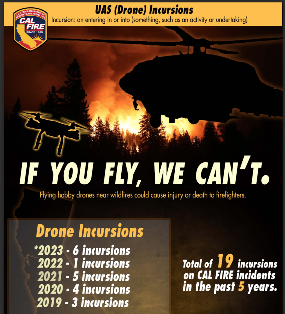
CAL FIRE Issues Urgent Warning Regarding Incursions of Unmanned Aircraft Systems
The state fire agency has issued an urgent warning regarding the incursion of Unmanned Aircraft Systems (UAS) into firefighting airspace. These incursions have raised serious concerns and led to the suspension of critical aerial firefighting operations on a half-dozen incidents so far this year.
Cal Fire incursions by the year
The FAA regularly establishes Temporary Flight Restrictions (TFRs) around wildfire areas to protect the safety of pilots and other aircraft crews working in firefighting operations. All aircraft, including drones, are explicitly prohibited from entering these restricted areas unless they are operated by an agency directly involved in the wildfire suppression efforts. Even when a TFR is not in effect, drone pilots are warned to avoid flying near wildfires — it is considered a crime to interfere with firefighting operations.
“The danger of flying drones near wildfires cannot be overstated,” said Chief Jake Sjolund, Staff Chief Tactical Air Operations. “Such actions jeopardize lives and have immediate consequences for firefighting agencies’ response efforts.”
When drones are detected near wildfires, fire response agencies will ground their own firefighting aircraft to mitigate the risk of a collision. This delay in airborne response on a fire threatens the safety of firefighters on the ground, residents, and properties in nearby communities.
Anyone who operates a drone without authorization near a wildfire can be found in violation of federal, state, and local laws, regulations, and ordinances — regardless of whether a TFR is in place. Anyone who interferes with wildfire suppression efforts with a drone can face severe consequences, including civil penalties of up to $20,000 and even criminal prosecution.
05/28/2023 UPDATE: On May 19 Montana Gov. Greg Gianforte signed Senate Bill 219. The law took effect immediately and made drone interference with aerial firefighting a misdemeanor crime publishable by a fine of up to $1,500, or jail time up to six months, or both. Unauthorized drone incursions over fires grounded aircraft on at least two Montana wildfires and two Idaho wildfires last year — part of over a dozen drone-related groundings nationwide. Drones flying around wildfires could collide with firefighting aircraft, distract pilots, or crash into vehicles or firefighters on the ground.
03/06/2023 — New legislation proposed to add criminal penalties for those who fly drones over wildfires and interfere with operations is making progress in Montana. Senate Bill 219 to “revise wildfire suppression laws,” with Democratic Sen. Willis Curdy as its primary sponsor, had its third reading on February 10. The vote was 37 YEA and 10 NAY with 3 other legislators excused.
Senate Bill 219 would designate flying a drone over a wildfire as a misdemeanor with a fine of up to $1,500 and six months in jail. Those charges could be made in addition to civil penalties, according to the Helena Independent Record.
Curdy described incidents near Helena last year in which drones interfered with firefighting operations and prosecutors said the drone pilots could not be prosecuted. The bill passed the Senate Natural Resources Committee unanimously after an amendment from Republican Sen. Barry Usher that would allow law enforcement to “use reasonable force” to disable a drone — including the authority to shoot down a drone.
Sen. Daniel Zolnikov of Billings cautioned that drone pilots unaware of the law and without the intent to interfere with operations might be unjustly punished, and the law wouldn’t stop all drone incursions into restricted airspace.
“We work really hard to fly safely,” Curdy told the Senate Natural Resources Committee. “We work really hard to keep our firefighters safe on the ground, and I think this bill’s intention is to move it in that direction.”
The Independent Record also noted that federal law prohibits interfering with firefighting aircraft, but this bill is specific to state and county jurisdiction. It has drawn universal support from firefighters and law enforcement personnel, who cited numerous incidents in which drones have required suspension of aviation operations, including incidents last year on both the Matt Staff Road fire east of Helena and the late summer fire on Mount Helena.
USFS graphic
Matthew Hall, fire protection bureau chief with the Montana Department of Natural Resources and Conservation, said that on the Mount Helena incident, six aircraft were working to keep the fire from residential areas when a drone was spotted.
“Because of the life-safety impacts drones pose to low-flying aircraft, the aerial initial attack operations were immediately suspended,” he said. “Not only was this a significant risk to aviators, but it severely limited our capabilities in fire suppression when they were needed most.”
Aerial Fire Magazine reported that Sen. Curdy is a former wildland firefighter and air attack supervisor; his facebook profile notes he spent 38 years as a wildland firefighter, 30 as a smokejumper — with additional creds as Former Pilot, Light Fixed Wing Manager, and Supervisory Pilot at U.S. Forest Service.
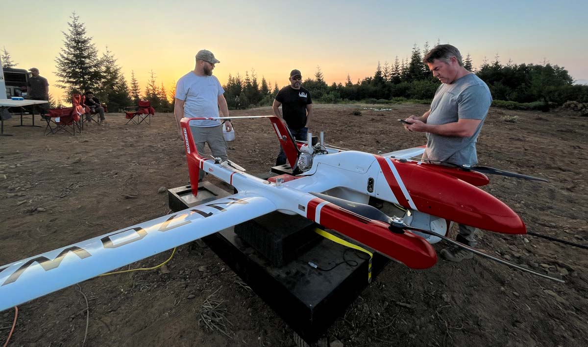
A contracted UAS crew with Precision Integrated Programs / Overwatch Aero — Tyler Kock, Daniel Rodriguez, and Cliff Savage — on the Lighting Complex of fires. US Forest Service photo by Andrew Avitt. FVR-90, N170WA.
By Andrew Avitt, US Forest Service, Pacific Southwest Region
Drones – also called UAS or unmanned aerial systems – are playing an increasingly important role in fighting wildfires by supporting operations with aerial ignition and gathering intelligence for firefighters. The greatest benefit drones provide is they can take to the sky when manned aircraft are grounded for pilot safety.
Take, for example the FVR-90, a fixed-wing drone with a 14-foot wingspan capable of traveling at speeds up to 46 mph with a flight time of 8 hours. They are sent airborne just at dusk when other manned flights are grounded. The sky is theirs, and the overhead view they have of the fire is detailed and in real time.
“The way we use UAS now is very much a supplement,” said Justin Baxter, the Forest Service National UAS Operations Specialist. “There are certain times that it’s just not safe for us to utilize manned helicopters or fixed-wing aircraft, like nighttime operations or in thick smoke or high winds.”
USFS photo by Andrew Avitt.
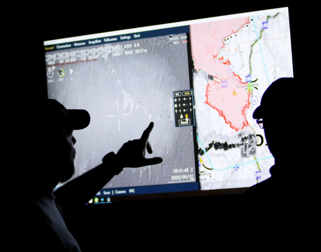
The drones that Baxter and his team fly are equipped with cameras that are not your normal cameras. They have multiple types of sensors, including infrared, that allow the team to see through smoke and, at night, see heat signatures, or thermal-based imaging. This allows the identification of areas where fire is still active and new areas where flames have advanced, such as spot fires.
Spot fires occur when embers from the main fire are thrown into the air and pushed by wind until they fall to the ground, starting a new fire. They are notoriously hard to identify because they are small at first and visibility is diminished by smoke. They may occur in hard-to-reach places difficult for firefighters to patrol, like on steep slopes or down in drainages.
“Drones are changing that labor-intensive process to identify these spot fires, especially when an operational area can span hundreds of thousands of acres,” Baxter said. With drones, fire managers and incident management teams can scan large areas quickly and easily identify spot fires that may be a mile from the main fire. That enables firefighters to get in and suppress those new starts before they grow.
“To give you an idea, this drone can detect a 2-inch by 2-inch spot fire from a half-mile away,” said Baxter as he gestured to the imposing drone just to his left minutes before takeoff to fly around the perimeter of the Six Rivers Lightning Complex Fire near Willow Creek, California.
Baxter said that much has changed since 2015 when the agency began the UAS program. With each passing year, incident management teams have increasingly incorporated the capability into their strategies.
The communication between the UAS crew and firefighters on the ground flows in both directions. The drone may be flying over and see heat in an area and transmit the information to a hotshot crew. Conversely, the hotshot crew can ask the UAS crew for assistance in exploring an area that they suspect might be active, and then view a feed from the drone of the area in question.
John Crotty served as the air operations branch director with California Interagency Incident Management Team 15 that responded to the Lightning Complex Fire on the Six Rivers National Forest.
A drone equipped for aerial ignition. USFS photo by Mike Yearwood.
Aerial intelligence isn’t new in wildland firefighting, said Crotty referring to the recently retired Cobra helicopter and its Firewatch capabilities. But the implications of unmanned flight— that opens up new possibilities.
“With the Cobra aircraft, we needed a pilot and an interpreter up there to run the camera and talk to the folks on the ground. So, we expose two individuals plus a flight [to risk],” said Crotty, “But what we really needed was the visibility to fly.”
Thick smoke on the fires like the Lightning Complex can ground manned aircraft. That’s where drones come into play and the images it captures can inform firefighters working across a large area.
“The other day I heard from one of the hotshot crews out there. They were in heavy smoke conditions, at night. With the low visibility they couldn’t see if they had a spot fire across the line,” Crotty said. “This tool being up in the air, looking down at that exact area, the UAS crew was able to pinpoint the spot and provide precise coordinates to the firefighters who were able to check it out and put it out. That kind of information we would never have without these unmanned aircraft and that capability. Drones are the future of aviation for not only fire but for aviation in general. It’s a win-win for the agencies to operate under an umbrella of this type of aircraft that can provide precise and timely info to firefighters and incident management teams. And most importantly, we can do it safely.”
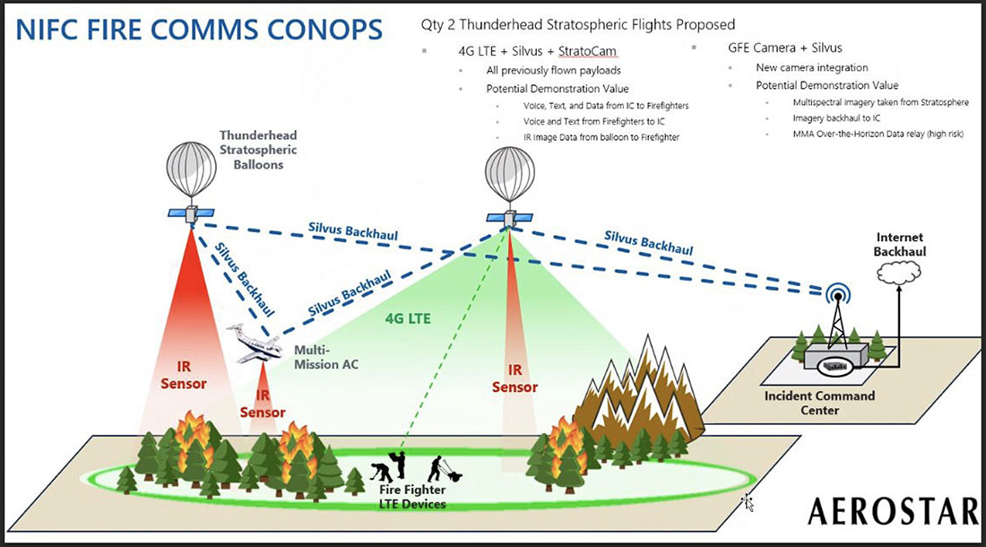
Illustration of how a Thunderhead Stratospheric balloon can assist wildland firefighters.
The US Forest Service is partnering with NASA to evaluate the use of two high-altitude long endurance drones to improve wildland firefighters’ situational awareness.
1. A balloon
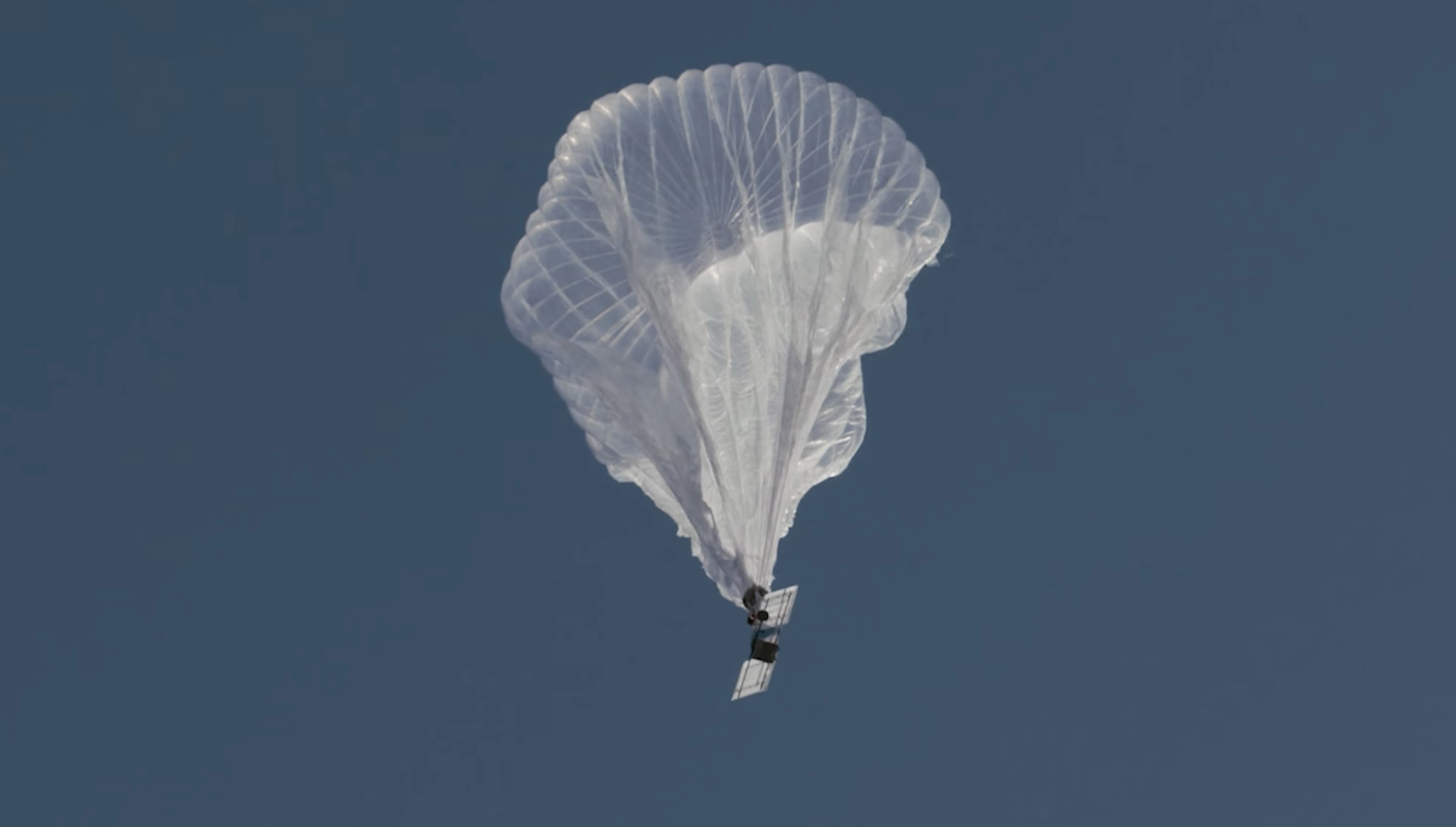
Last week a balloon laden with a sophisticated package of electronics hovered 60,000 feet over the Moose Fire in Idaho. Its mission was to assist firefighters in improving and maintaining situational awareness. Some of them may have seen the shiny object the size of a football stadium, even though it was more than 11 miles above the incident.
The company that built and operates the aircraft, Aerostar, calls it STRATO, or Strategic Radio and Tactical Overwatch, a technology that is in the research and development phase.
File photo of a partially inflated Raven Aerostar balloon just after launch. Still image from Aerostar video.
The STRATO is basically a giant mylar balloon with solar panels, batteries, radio equipment, cameras, and sensors. It has the capability to collect infrared and visual data, broadcast an LTE (cell phone) signal, has a high-band radio that can enable push to talk communications, and can operate a WiFi network. The huge helium balloon can hover over an incident in the stratosphere taking pictures, delivering data to incident managers, and providing communications options to the Incident Command Post and crews on the ground.
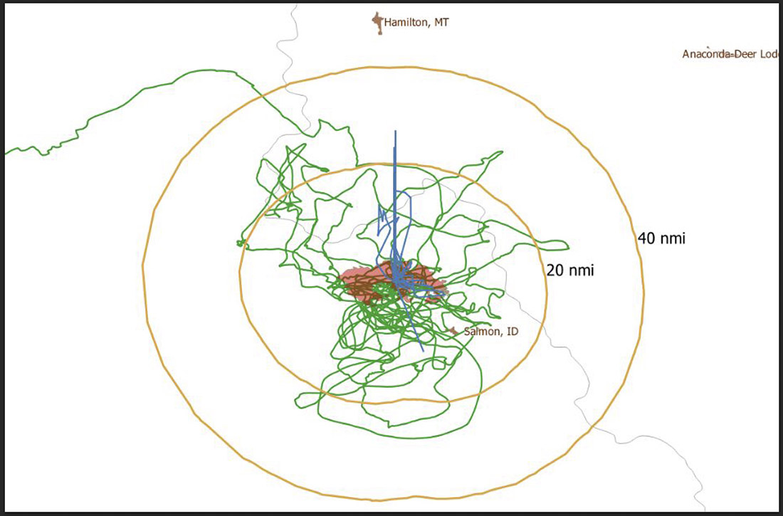
Flight path of an Aerostar Thunderhead Stratospheric balloon over the Moose Fire the week of August 7, 2022.
Last October Fire Aviation wrote about the system operated by Aerostar, a company based near Sioux Falls, South Dakota, which has been working with lighter than air technologies since 1956. We contacted the Communications Manager for the company, Lisa McElrath, who told us that in June, July, and August of 2021 they launched one of their Thunderhead Balloons from South Dakota and flew it west to monitor wildfires. While traveling more than 16,000 miles during its 70-day flight it engaged in station-seeking above four active fires for the company’s research and development. It collected visible and thermal imagery data for extended periods of time on the Robertson Draw Fire (Montana), the Dixie Fire (California), the Dixie-Jumbo Fire (Idaho), and the Dry Gulch/Lick Creek Fire (Washington).
In October we asked Ms. McElrath if Aerostar had been cooperating with the federal land management agencies in mapping fires. She said not yet, but that representatives from the National Interagency Fire Center had reached out to them and expressed interest in discussions after the fire season slowed down. But this year the US Forest Service is officially cooperating in the pilot project.
“We can provide real-time imagery from the balloon today in the visible and infrared,” Ms. McElrath said. “In the future, the goal would be to automate the detection and download of critical imagery, fire perimeters, likely fire-starts, and other key information via onboard processing so that more actionable information would be available. We see stratospheric balloon technology being the key to cost-effective, scalable wildfire surveillance that reduces time between new fire detection and response. Effectively, balloons can alert firefighters to a new fire while it is still small, before the fire grows into something newsworthy and very expensive.”
She said the balloons can also serve as radio repeaters for personnel on the ground and could collect information from tracking devices on firefighting resources which could then be displayed on a map.
More flights over fires are being planned, said Sean Triplett, Team Lead for Tools and Technology, U.S. Forest Service, Fire and Aviation Management. He said NASA is matching the funding the Forest Service is putting toward the flights this year.
2. Fixed wing aircraft
Swift Engineering’s SULE HALE-UAS. Swift Engineering photo.
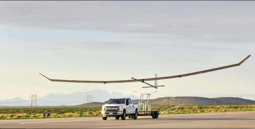
Another High Altitude Long Endurance (HALE) aircraft the Forest Service is looking at is Swift Engineering’s SULE HALE-UAS, capable of staying aloft for more than 30 days at a time. The Forest Service, again partnering with NASA, has issued a contract with the company and as of March 31, 2021 they had conducted more than 10 demonstrations of the solar powered fixed wing aircraft.
The key to long duration flight using solar power on an airplane is to have a top surface area large enough for the solar cells needed to power the electric motors day and night, using a battery for night operations. Large wings mean more solar cells, but also more wind resistance. So the answer, using today’s technology, is to fly very high at 60,000 to 70,000 feet where the air is thin, the sunlight on the solar panels is strong, and there is less wind resistance.
The SULE, which took its first flight in July of 2020 has a 72-foot wingspan, operates at 70,000 feet, and can carry a payload of 15 to 22 pounds.
“A series of mid-altitude and high-altitude flights is being undertaken, Mr. Triplett told Fire Aviation on Wednesday. “At this point, the platform is only providing remote sensing products. However, if successful, additional systems may be incorporated.” Those added systems could include a radio system to provide connectivity enabling the tracking of firefighting resources on the ground in addition to live imagery of the fire.
Mr. Triplett said one advantage of having NASA as part of the project is that they can handle the airworthiness of the aircraft and interactions with the FAA.
The Swift Engineering video below shows what may be the first flight of the SULE two years ago.
A step toward the Holy Grail of Wildland Firefighter Safety?
Our view is that providing to wildland fire supervisors the real time location of both the fire and firefighting resources is the Holy Grail of Wildland Firefighting Safety. Lacking this information has led to at least two dozen firefighter fatalities. These High Altitude Long Endurance aircraft 13 miles above the fire could be an important link to transmit live video of the fire to personnel and provide radio connectivity enabling the tracking of firefighting resources on the ground even when they are in steep rugged topography. Of course the resources would need to have the hardware necessary to transmit the coordinates of their locations.
The John D. Dingell, Jr. Conservation, Management, and Recreation Act which became law March 12, 2019 required that by March 12, 2021 the five federal land management agencies “…develop consistent protocols and plans for the use on wildland fires of unmanned aircraft system technologies, including for the development of real-time maps of the location of wildland fires.”
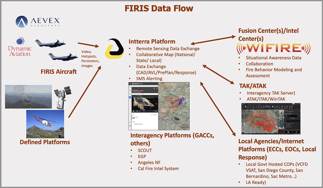
While this technology has been demonstrated, real time mapping appears to be far from being used routinely, at least within the Federal agencies. But at the state level, the Governor of California has requested $30 million in their next budget for 31 positions and funds for the state’s Office of Emergency Services to operate Real-Time Intelligence System (FIRIS) aircraft that have shown that they can provide real time fire mapping information. A pilot program for FIRIS first got off the ground September 1, 2019 thanks to funding secured in the 2019-2020 California state budget. This year two FIRIS ships have been assisting firefighters.
The Dingell Act also mandated that the five federal land management agencies “jointly develop and operate a tracking system to remotely locate the positions of fire resources for use by wildland firefighters, including, at a minimum, any fire resources assigned to Federal type 1 wildland fire incident management teams”, again, due by March 12, 2021.
Other solar powered high-altitude aircraft
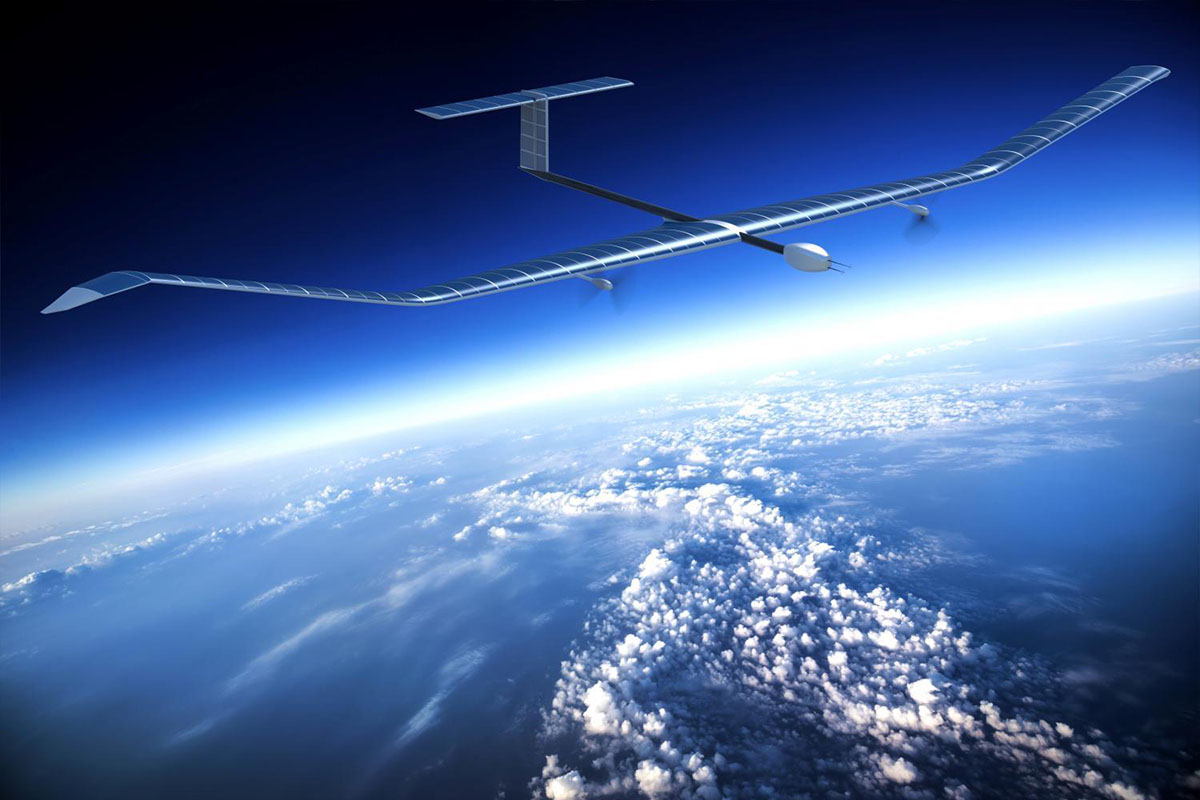
An aircraft that the Forest Service is not involved with is the Zephyr, made by AIRBUS. It is an unmanned, solar-powered fixed wing aircraft designed to stay aloft at high altitude for months.
AIRBUS Zephyr, stratospheric unmanned aerial vehicle. Airbus image.
In its latest test flight that began June 15, 2022 the Zephyr took off from the U.S. Army’s Yuma, Arizona Proving Ground and has been flying patterns over the Yuma Test Range and Kofa National Wildlife Refuge ever since. Now 63 days later the flight has smashed Zephyr’s previous record of 25 days that it set in August 2018. When we checked August 17 it was cruising at 40 knots ground speed 70,500 feet above the Earth.
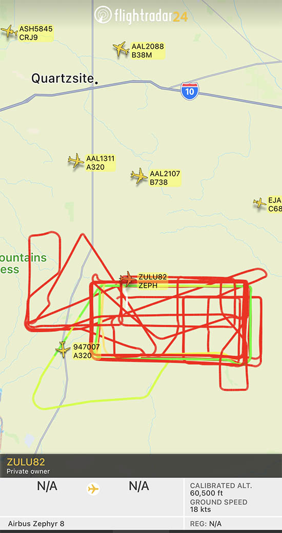
Flight path of ZULU82 Zephyr, a solar-powered unmanned aircraft on August 16, 2022, day 62 of a flight that began June 15, 2022.
UPDATE at 7:32 p.m. MDT August 21, 2022
The flight of the Zephyr has ended.
“Following 64 days of stratospheric flight and the completion of numerous mission objectives, Zephyr experienced circumstances that ended its current flight. No personal injury occurred,” AIRBUS said in a statement.
Simple Flying reported that a catastrophic loss of altitude occured on August 19 after flying for 64 days straight:
On its final day of operations, it was tracking around over the vast Arizona Desert, about halfway between Phoenix and Mexicali, Baja California. Flying slightly lower than was typical, at some 45,000 – 50,000 feet, it had completed an S-shape maneuver at around 50 – 60 knots when something went catastrophically wrong. ADSB data shows a vertical descent rate which rapidly increased, topping out at a speed of 4,544 feet per minute. Although unconfirmed by Airbus, it does seem that the Zephyr met a rather unglamorous end.
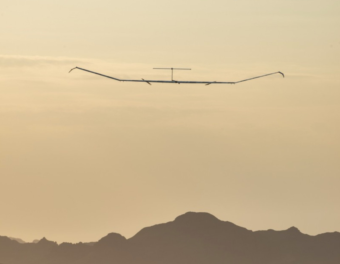
The Airbus Zephyr S during a 2021 test flight. US Army photo.
Drone being used to assist wildland firefighters. Drone Amplified photo.
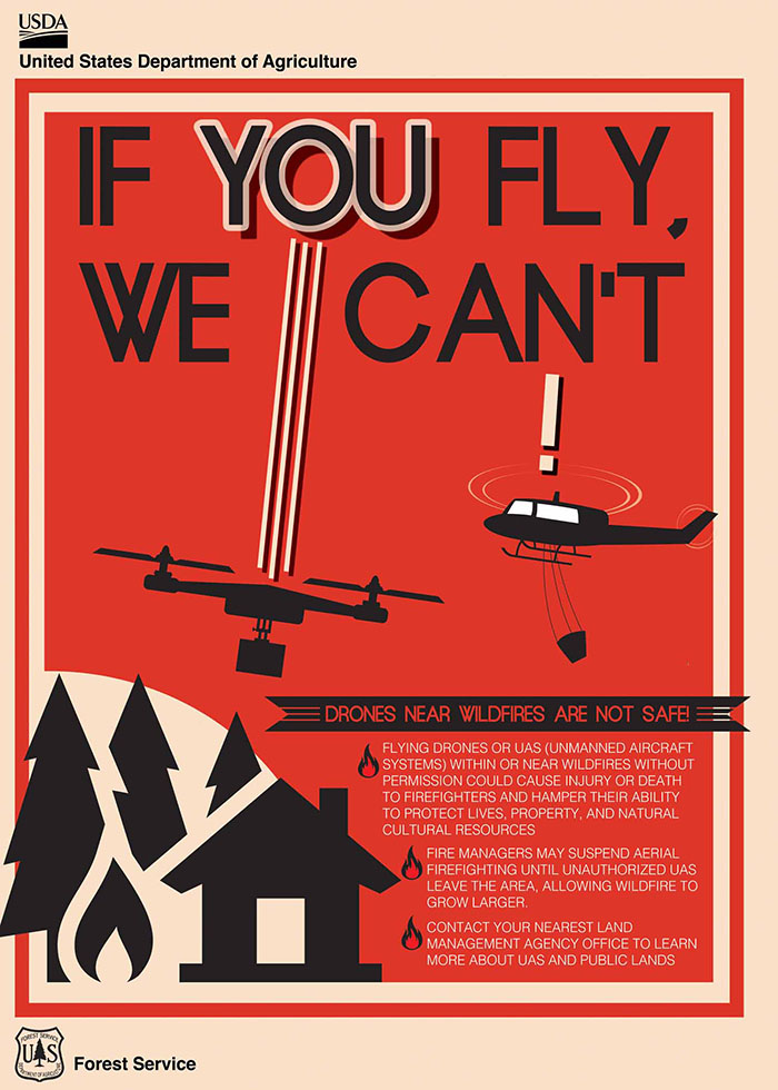
The Federal Bureau of Investigation is using a new system to help wildland firefighters by detecting, identifying, and neutralizing drones that are illegally interfering with firefighting activities.
It is very dangerous to fly a drone near a fire at which helicopters or fixed wing aircraft are operating. A collision could impact the windscreen or damage the engine, props, rotors, or flight control surfaces, causing a crash. If a drone is seen near a fire the standard operating procedure is to remove all aircraft from the fire area until it is confirmed that the drone has left the scene. In other words, it interferes with firefighting efforts.
The FBI is working with the Los Angeles County Fire Department to use a system that can detect a drone flying over a fire within 30 seconds of it being launched.
From CNN:
“When the detection equipment finds the drone and identifies the operator’s location, we can very rapidly get that information to a ground intercept team who can then go make contact with that drone operator and essentially get them to stop flying that drone,” said James Peaco III, the weapons of mass destruction coordinator for the FBI’s Los Angeles field office.
With a special sensor, the team can set up a boundary as large or as small as desired and get notified if a drone flies into that area, instantly obtaining precise details such as elevation, direction, speed as well as where the drone took off from and where the controller is currently standing.
“The first thing we do is order them to bring the drone back, explain to him that there’s a wildfire and flying that drone during a wildland fire is actually a federal felony,” Peaco said.
It’s a federal crime punishable by up to 12 months in prison to interfere with firefighting efforts on public lands. Additionally, Congress has authorized the FAA to impose a civil penalty of up to $20,000 against any drone pilot who interferes with wildfire suppression, law enforcement, or emergency response operations. The FAA treats these violations seriously, and will immediately consider swift enforcement action for these offenses.
According to the US Forest Service, in 2019 at least 20 documented instances of unauthorized drone flights over or near wildfires in seven states (Arizona, California, Colorado, Nevada, New Mexico, Utah, Washington and Minnesota) resulted in aerial firefighting operations being temporarily shut down nine times. There is no centralized national mechanism to report unauthorized UAS flights over wildfires, so these are only the incidents that wildfire management agencies have become aware of, there are likely more that are not known about.
Suspending air operations could decrease the effectiveness of wildfire suppression operations, allowing wildfires to grow larger, and in some cases, unduly threaten lives, property, and valuable natural and cultural resources. The effects of lost aircraft time could be compounded by flames moving into untreated terrain.
Thanks and a tip of the hat go out to Tom and Gerald.
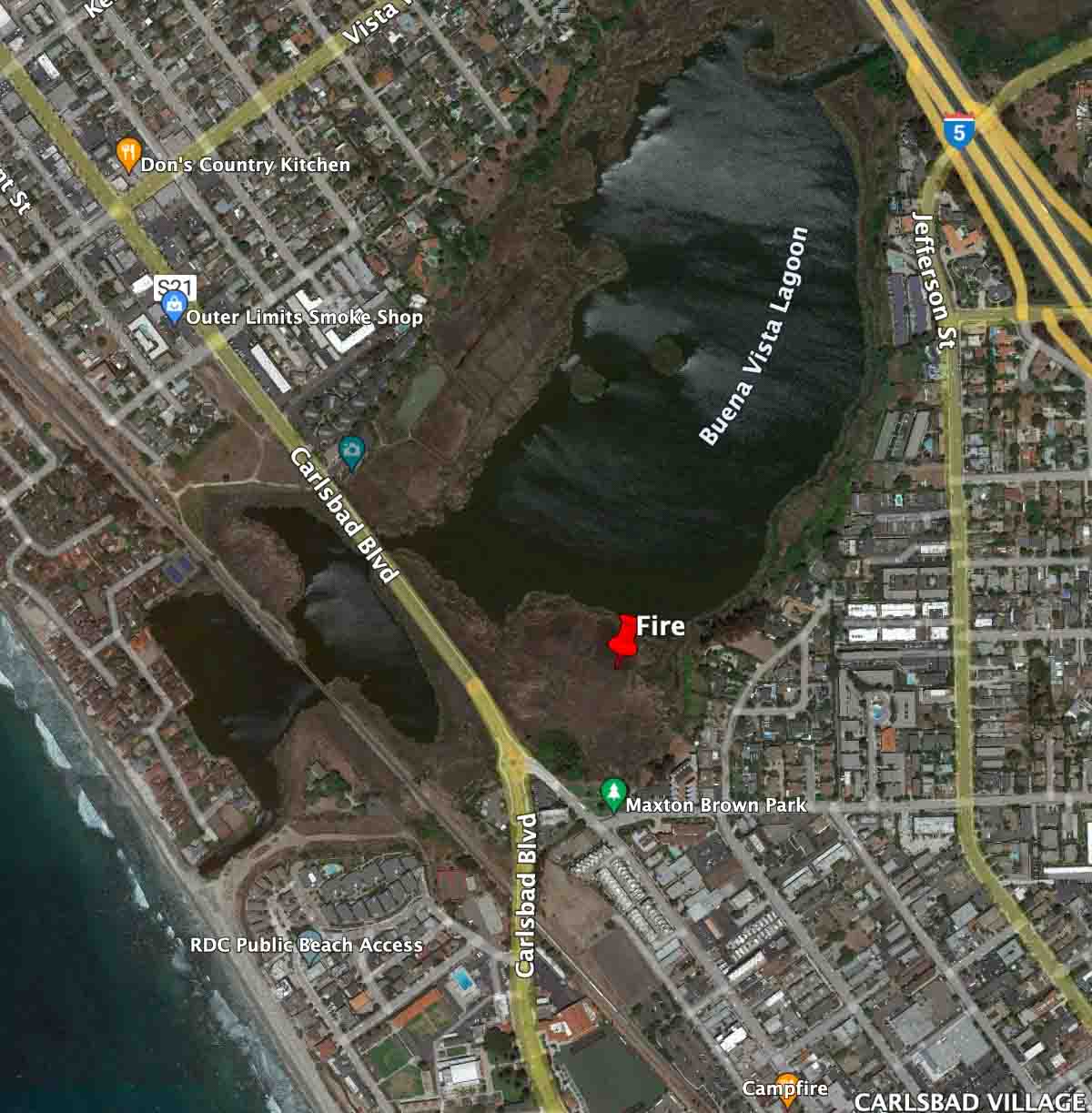
A drone pilot posted aerial video illegally shot of the fire while a helicopter was dropping water
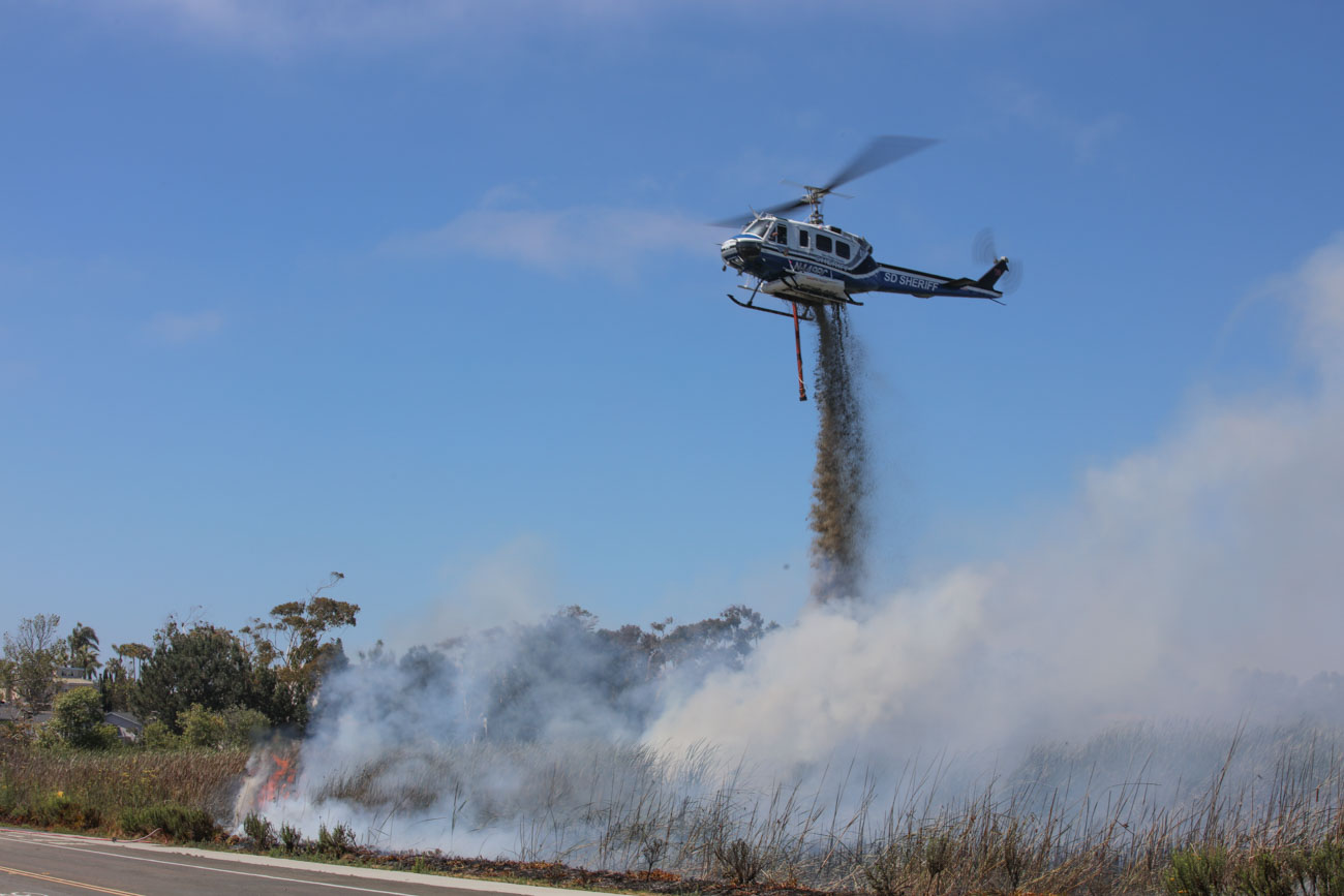
A San Diego County Bell 205, (N449RC) drops on a fire in Carlsbad, CA June 25, 2022. Photo by Ryan Grothe.
Ryan Grothe got some photos of one of the San Diego County Sheriff Department’s Bell 205 helicopters, H- 10 (N449RC), as it assisted firefighters battling a 10-acre fire in the Buena Vista Lagoon June 25, 2022 near Carlsbad, California between Carlsbad Blvd. and Interstate 5.
Evacuations were in effect for a while but no structures were damaged.
The police arrested and charged David Prosser, a 59-year-old man from Carlsbad, with arson and resisting arrest.
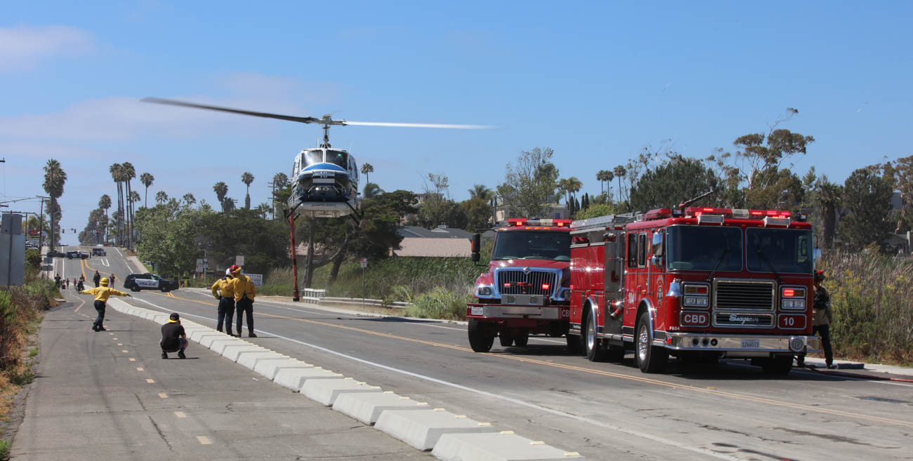
San Diego County Helicopter 10 (N449RC) at a fire near Carlsbad Blvd. June 25, 2022. Photo by Ryan Grothe.
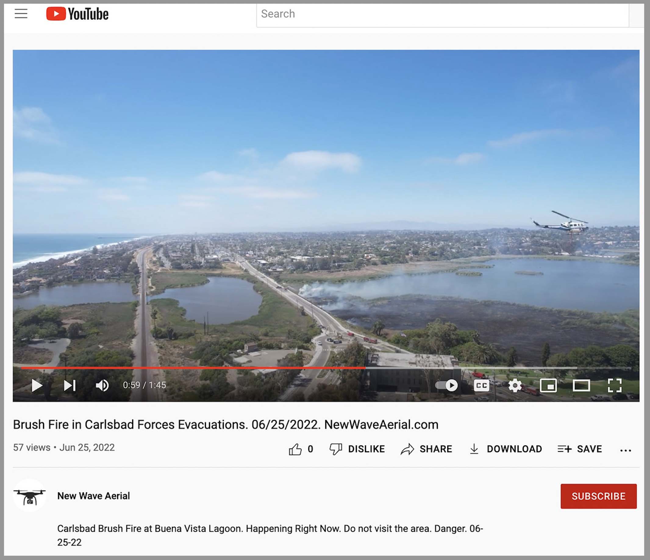
A drone was illegally flying near the fire
Within hours after the spread of the fire was stopped, a drone video with aerial footage of the incident was posted on YouTube by New Wave Aerial. The video includes a very clear shot of Helicopter 10 flying toward the drone at about the same altitude then banking to the left as it maneuvered prior to dropping a load of water on the fire. It is difficult to tell how close the two aircraft were without knowing what type of lens the drone was using, but they may have been just a few hundred feet apart.
Still image from video posted by New Wave Video shot near the fire in Carlsbad, CA June 25, 2022. The helicopter, seen on the right, had just banked to its left after flying toward the drone.
It is very dangerous to fly a drone over a fire at which helicopters or fixed wing aircraft are operating. A collision could impact the windscreen or damage the engine, props, rotors, or flight control surfaces causing a crash. If a drone is seen near a fire the standard operating procedure is to remove all aircraft from the fire area until it is confirmed that the drone has left the scene. In other words, it interferes with firefighting efforts.
Sergeant G. Lanning of the San Diego County Sheriff’s Astrea helicopter division told Fire Aviation that they were not aware that the drone was at the fire. If it had been spotted, it would have shut down the aviation operation at the fire, he said.
Calls to the FAA and New Wave Video were not immediately returned.
The rules
The FAA often implements Temporary Flight Restrictions (TFRs) around wildfires to protect aircraft that are involved in the firefighting operation. All aircraft, including drones, are prohibited from flying in the restricted area unless they’re operated by an agency that’s involved in the firefighting operation. Even if a TFR is not in place, drone pilots should avoid flying near wildfires. It’s a federal crime to interfere with firefighting aircraft regardless of whether restrictions are established, and violators can face stiff penalties.
Fire Traffic Area
It is common on a fire whether or not a TFR is in force, to establish a Fire Traffic Area (FTA) over a fire to provide a standardized initial attack airspace structure and protocol to enhance traffic separation over wildfires. An aircraft should NOT enter the FTA until it receives a clearance. The standard FTA utilizes a minimum 5 nautical mile radius from the incident, although a radius greater than 5 miles may be utilized if needed by the incident.
Penalties
It’s a federal crime punishable by up to 12 months in prison to interfere with firefighting efforts on public lands. Additionally, Congress has authorized the FAA to impose a civil penalty of up to $20,000 against any drone pilot who interferes with wildfire suppression, law enforcement, or emergency response operations. The FAA treats these violations seriously, and will immediately consider swift enforcement action for these offenses.
According to the US Forest Service, in 2019 at least 20 documented instances of unauthorized drone flights over or near wildfires in seven states (Arizona, California, Colorado, Nevada, New Mexico, Utah, Washington and Minnesota) resulted in aerial firefighting operations being temporarily shut down nine times. There is no centralized national mechanism to report unauthorized UAS flights over wildfires, so these are only the incidents that wildfire management agencies have become aware of, there are likely more that are not known about.
Suspending air operations could decrease the effectiveness of wildfire suppression operations, allowing wildfires to grow larger, and in some cases, unduly threaten lives, property, and valuable natural and cultural resources. The effects of lost aircraft time could be compounded by flames moving into untreated terrain.
Still image from the Unmanned Aerial System Aerial Ignition Academy video, which is below.
The Unmanned Aerial System Aerial Ignition Academy trains personnel in the use of drones on prescribed fires and wildfires. The video below is a brief description of the academy.