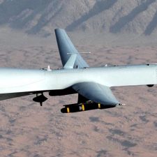
The US Forest Service is partnering with NASA to evaluate the use of two high-altitude long endurance drones to improve wildland firefighters’ situational awareness.
1. A balloon
Last week a balloon laden with a sophisticated package of electronics hovered 60,000 feet over the Moose Fire in Idaho. Its mission was to assist firefighters in improving and maintaining situational awareness. Some of them may have seen the shiny object the size of a football stadium, even though it was more than 11 miles above the incident.
The company that built and operates the aircraft, Aerostar, calls it STRATO, or Strategic Radio and Tactical Overwatch, a technology that is in the research and development phase.
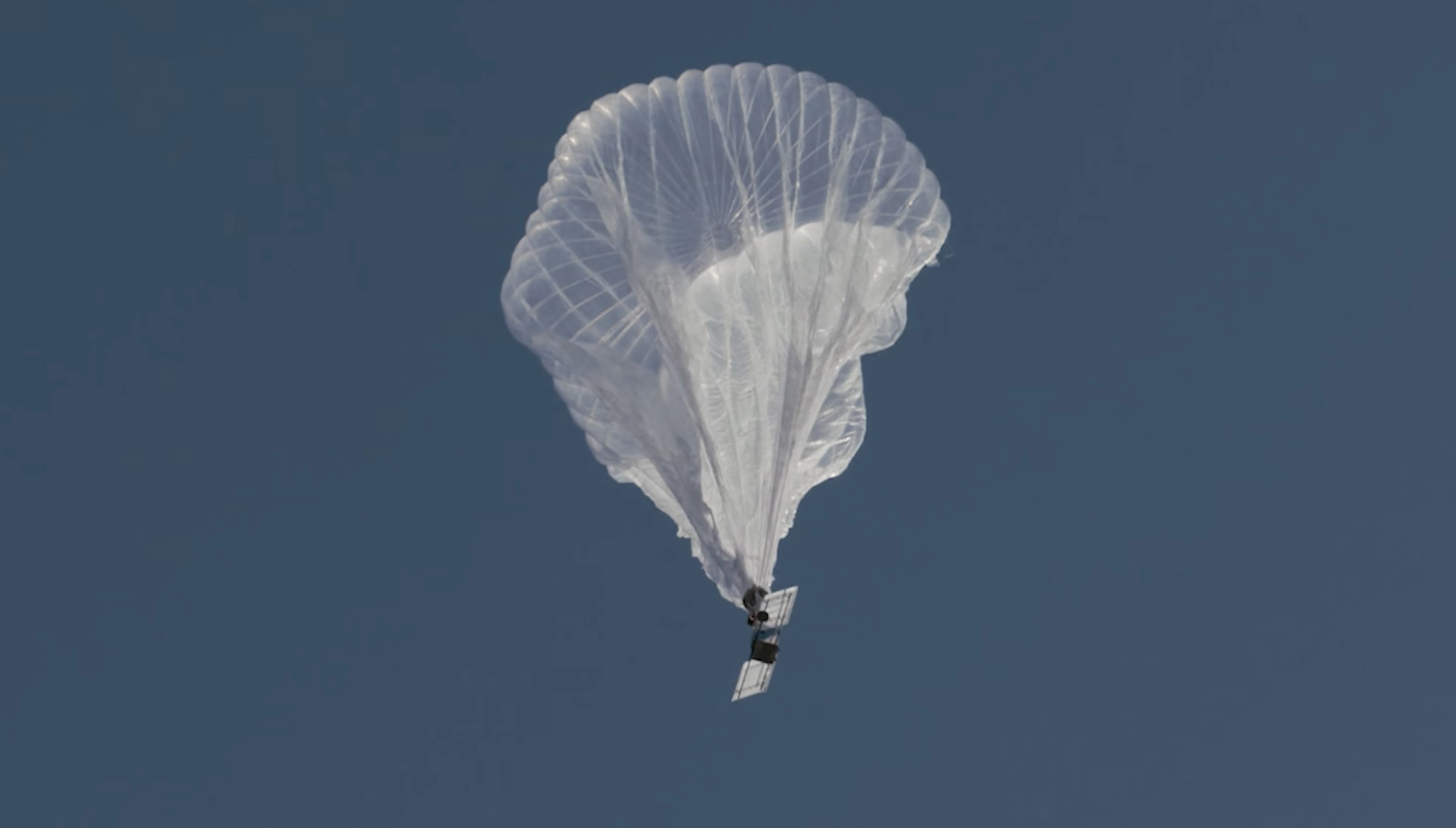
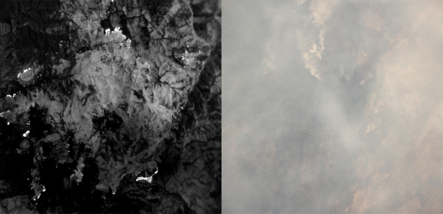
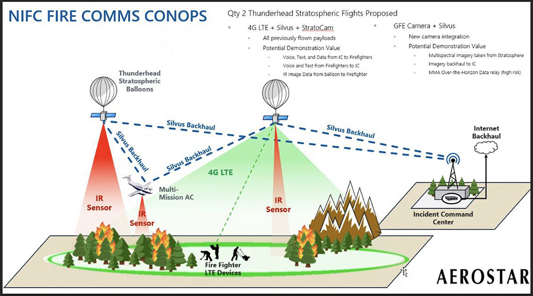
The STRATO is basically a giant mylar balloon with solar panels, batteries, radio equipment, cameras, and sensors. It has the capability to collect infrared and visual data, broadcast an LTE (cell phone) signal, has a high-band radio that can enable push to talk communications, and can operate a WiFi network. The huge helium balloon can hover over an incident in the stratosphere taking pictures, delivering data to incident managers, and providing communications options to the Incident Command Post and crews on the ground.
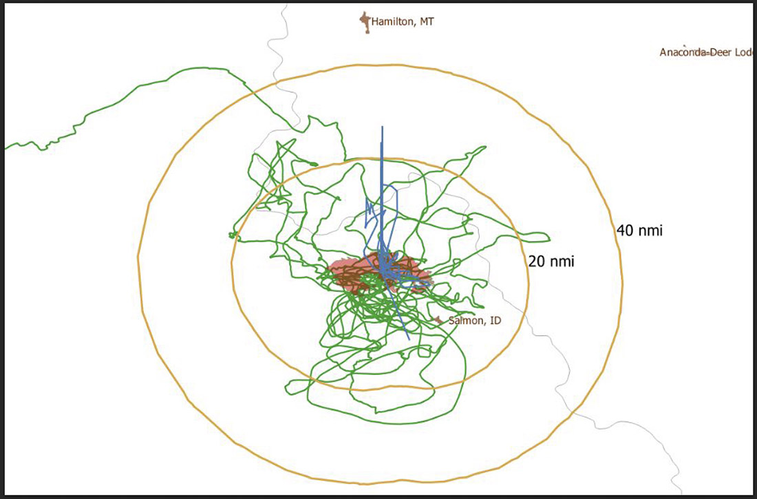
Last October Fire Aviation wrote about the system operated by Aerostar, a company based near Sioux Falls, South Dakota, which has been working with lighter than air technologies since 1956. We contacted the Communications Manager for the company, Lisa McElrath, who told us that in June, July, and August of 2021 they launched one of their Thunderhead Balloons from South Dakota and flew it west to monitor wildfires. While traveling more than 16,000 miles during its 70-day flight it engaged in station-seeking above four active fires for the company’s research and development. It collected visible and thermal imagery data for extended periods of time on the Robertson Draw Fire (Montana), the Dixie Fire (California), the Dixie-Jumbo Fire (Idaho), and the Dry Gulch/Lick Creek Fire (Washington).
In October we asked Ms. McElrath if Aerostar had been cooperating with the federal land management agencies in mapping fires. She said not yet, but that representatives from the National Interagency Fire Center had reached out to them and expressed interest in discussions after the fire season slowed down. But this year the US Forest Service is officially cooperating in the pilot project.
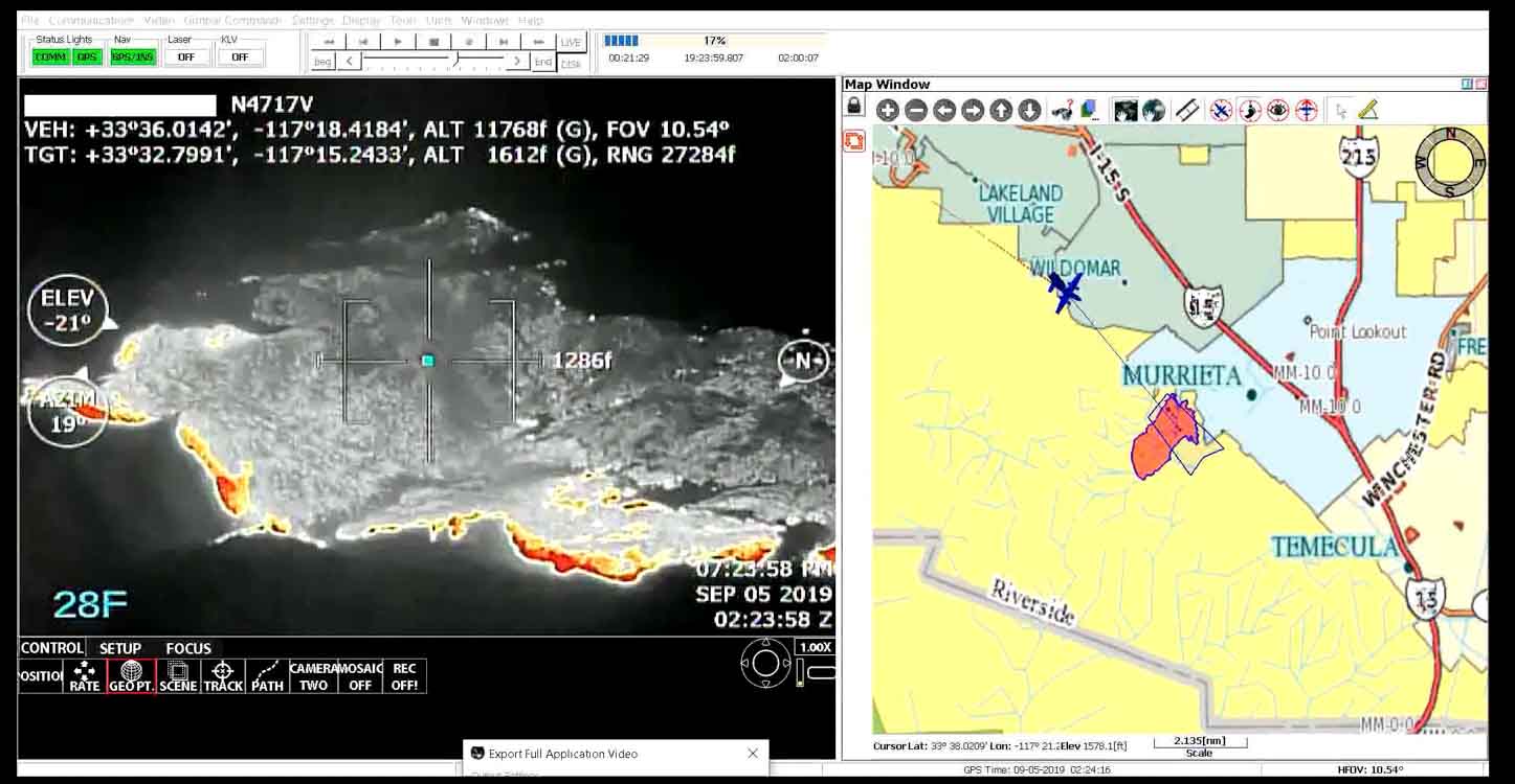
“We can provide real-time imagery from the balloon today in the visible and infrared,” Ms. McElrath said. “In the future, the goal would be to automate the detection and download of critical imagery, fire perimeters, likely fire-starts, and other key information via onboard processing so that more actionable information would be available. We see stratospheric balloon technology being the key to cost-effective, scalable wildfire surveillance that reduces time between new fire detection and response. Effectively, balloons can alert firefighters to a new fire while it is still small, before the fire grows into something newsworthy and very expensive.”
She said the balloons can also serve as radio repeaters for personnel on the ground and could collect information from tracking devices on firefighting resources which could then be displayed on a map.
More flights over fires are being planned, said Sean Triplett, Team Lead for Tools and Technology, U.S. Forest Service, Fire and Aviation Management. He said NASA is matching the funding the Forest Service is putting toward the flights this year.
2. Fixed wing aircraft
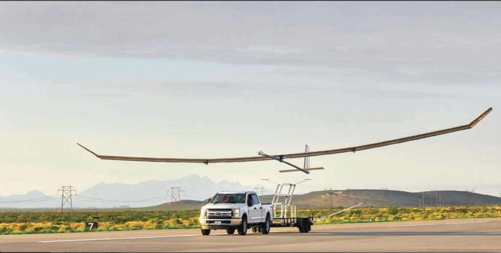
Another High Altitude Long Endurance (HALE) aircraft the Forest Service is looking at is Swift Engineering’s SULE HALE-UAS, capable of staying aloft for more than 30 days at a time. The Forest Service, again partnering with NASA, has issued a contract with the company and as of March 31, 2021 they had conducted more than 10 demonstrations of the solar powered fixed wing aircraft.
The key to long duration flight using solar power on an airplane is to have a top surface area large enough for the solar cells needed to power the electric motors day and night, using a battery for night operations. Large wings mean more solar cells, but also more wind resistance. So the answer, using today’s technology, is to fly very high at 60,000 to 70,000 feet where the air is thin, the sunlight on the solar panels is strong, and there is less wind resistance.
The SULE, which took its first flight in July of 2020 has a 72-foot wingspan, operates at 70,000 feet, and can carry a payload of 15 to 22 pounds.
“A series of mid-altitude and high-altitude flights is being undertaken, Mr. Triplett told Fire Aviation on Wednesday. “At this point, the platform is only providing remote sensing products. However, if successful, additional systems may be incorporated.” Those added systems could include a radio system to provide connectivity enabling the tracking of firefighting resources on the ground in addition to live imagery of the fire.
Mr. Triplett said one advantage of having NASA as part of the project is that they can handle the airworthiness of the aircraft and interactions with the FAA.
The Swift Engineering video below shows what may be the first flight of the SULE two years ago.
A step toward the Holy Grail of Wildland Firefighter Safety?
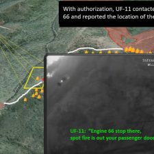
Our view is that providing to wildland fire supervisors the real time location of both the fire and firefighting resources is the Holy Grail of Wildland Firefighting Safety. Lacking this information has led to at least two dozen firefighter fatalities. These High Altitude Long Endurance aircraft 13 miles above the fire could be an important link to transmit live video of the fire to personnel and provide radio connectivity enabling the tracking of firefighting resources on the ground even when they are in steep rugged topography. Of course the resources would need to have the hardware necessary to transmit the coordinates of their locations.
The John D. Dingell, Jr. Conservation, Management, and Recreation Act which became law March 12, 2019 required that by March 12, 2021 the five federal land management agencies “…develop consistent protocols and plans for the use on wildland fires of unmanned aircraft system technologies, including for the development of real-time maps of the location of wildland fires.”
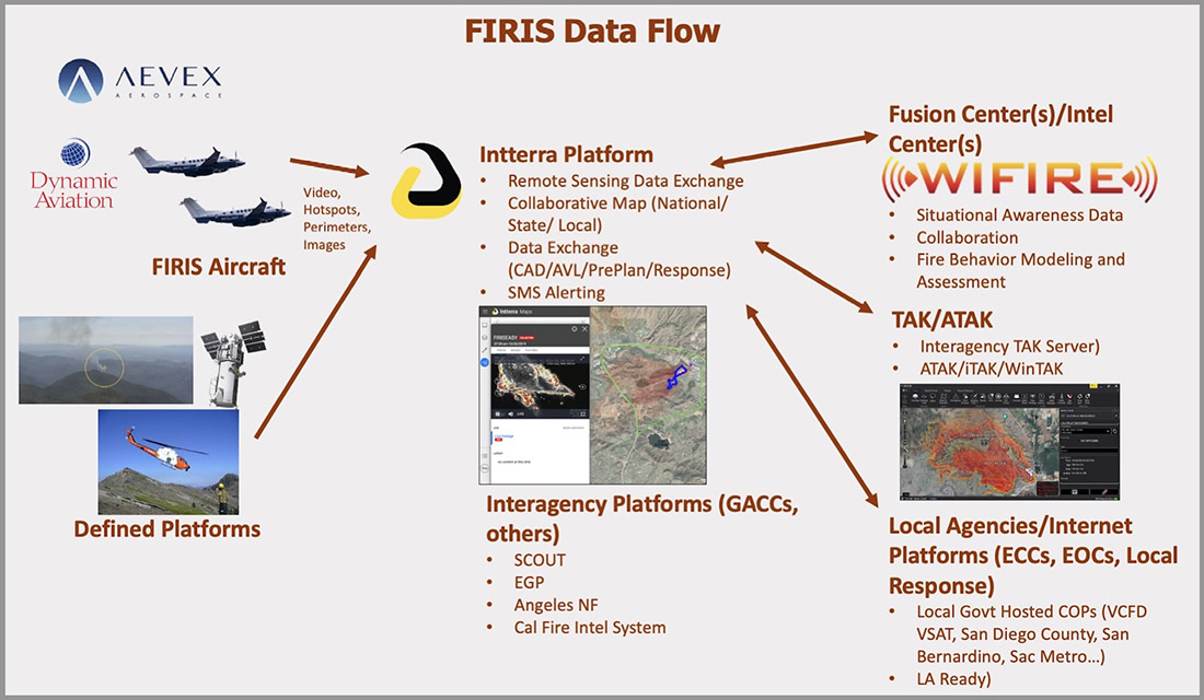
While this technology has been demonstrated, real time mapping appears to be far from being used routinely, at least within the Federal agencies. But at the state level, the Governor of California has requested $30 million in their next budget for 31 positions and funds for the state’s Office of Emergency Services to operate Real-Time Intelligence System (FIRIS) aircraft that have shown that they can provide real time fire mapping information. A pilot program for FIRIS first got off the ground September 1, 2019 thanks to funding secured in the 2019-2020 California state budget. This year two FIRIS ships have been assisting firefighters.
The Dingell Act also mandated that the five federal land management agencies “jointly develop and operate a tracking system to remotely locate the positions of fire resources for use by wildland firefighters, including, at a minimum, any fire resources assigned to Federal type 1 wildland fire incident management teams”, again, due by March 12, 2021.
Other solar powered high-altitude aircraft
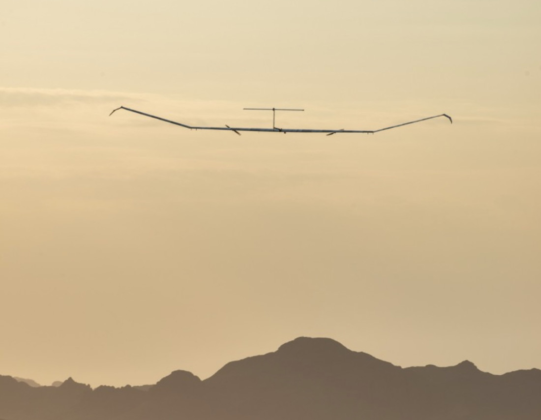
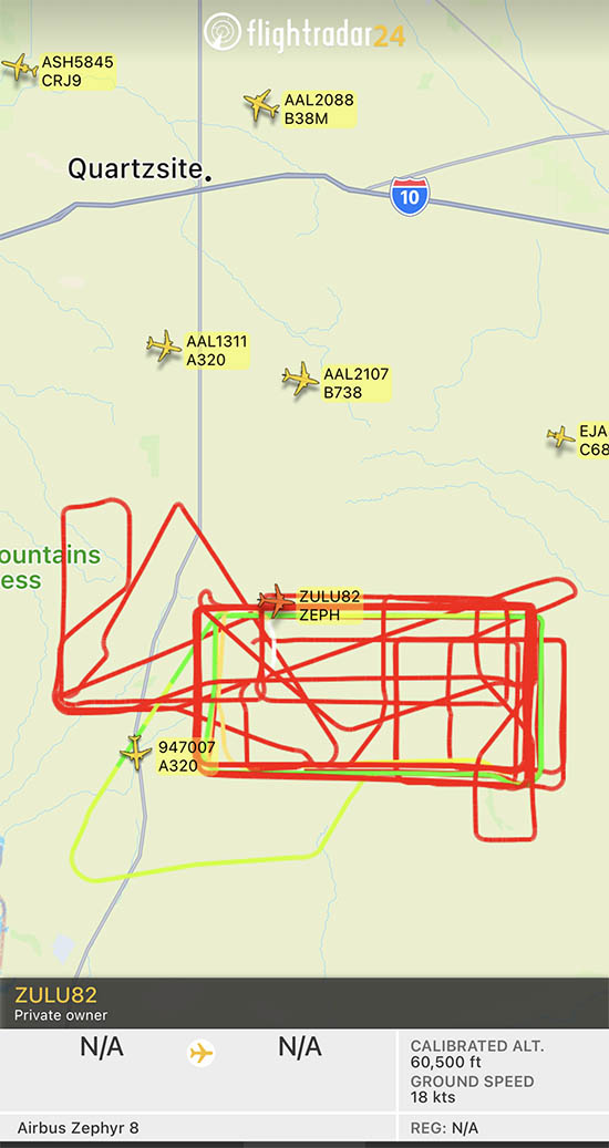
An aircraft that the Forest Service is not involved with is the Zephyr, made by AIRBUS. It is an unmanned, solar-powered fixed wing aircraft designed to stay aloft at high altitude for months.

In its latest test flight that began June 15, 2022 the Zephyr took off from the U.S. Army’s Yuma, Arizona Proving Ground and has been flying patterns over the Yuma Test Range and Kofa National Wildlife Refuge ever since. Now 63 days later the flight has smashed Zephyr’s previous record of 25 days that it set in August 2018. When we checked August 17 it was cruising at 40 knots ground speed 70,500 feet above the Earth.
UPDATE at 7:32 p.m. MDT August 21, 2022
The flight of the Zephyr has ended.
“Following 64 days of stratospheric flight and the completion of numerous mission objectives, Zephyr experienced circumstances that ended its current flight. No personal injury occurred,” AIRBUS said in a statement.
Simple Flying reported that a catastrophic loss of altitude occured on August 19 after flying for 64 days straight:
On its final day of operations, it was tracking around over the vast Arizona Desert, about halfway between Phoenix and Mexicali, Baja California. Flying slightly lower than was typical, at some 45,000 – 50,000 feet, it had completed an S-shape maneuver at around 50 – 60 knots when something went catastrophically wrong. ADSB data shows a vertical descent rate which rapidly increased, topping out at a speed of 4,544 feet per minute. Although unconfirmed by Airbus, it does seem that the Zephyr met a rather unglamorous end.