Operator of illegal drone at Pinal Fire cited

This drone intrusion seriously compromised active helicopter operations at the Helibase and prevented an incident helicopter from returning from its mission until the intrusion was cleared.

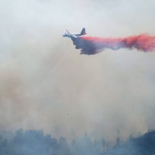
Above: a P2V air tanker drops on the northern end of the Pinal Fire south of Globe, Arizona on May 24, 2017. Inciweb photo.

Drones operating illegally at the Pinal Fire south of Globe, Arizona have interfered with aviation operations four times since the fire started. One of those intrusions resulted in the drone being confiscated and the operator cited. Below is the text of a Rapid Lesson Sharing document about the incident, distributed by the Wildland Fire Lessons Learned Center.

****

“On May 20 at approximately 1805, an Unmanned Aerial Systems (UAS)—or drone—was spotted 60 yards from the Pinal Fire Helibase at approximately 50 feet above ground level.

The UAS was flying in the designated flight path of this incident’s helicopters where they were making their descents to land at the Pinal Fire Helibase, located within the city limits of Globe, Arizona. The UAS was white in color and approximately two feet in diameter.

Upon seeing the UAS, Helibase personnel contacted Helicopter 0TA, an incident helicopter that was flying a mission over the fire, to inform the pilot of the UAS intrusion into the Temporary Flight Restriction (TFR) and the hazard associated with the UAS being in the area.

The helicopter was asked to not come back to the Helibase until fire personnel were sure that the UAS was clear of the area. The Helibase Manager immediately called the Air Operations Branch Director (AOBD) to inform him of the UAS intrusion. The AOBD, in turn, contacted incident Law Enforcement—who responded immediately to the Helibase.

Helitack personnel were able to track the UAS while it was in flight. They were proactive in tracking the UAS and following its flight path. They observed the aircraft descend and land at a nearby residence in the vicinity of the Pinal Fire Incident Command Post.

UAS (Drone) Operator Located and Cited

The LEO arrived at the Helibase. He was informed of the location where the UAS descended and landed. The LEO had enough information to go make contact with the UAS operator and was able to confiscate the UAS and cite the individual.

This UAS intrusion within the TFR posed a serious safety concern for incident pilots and fire personnel involved in helicopter aviation missions on the Pinal Fire. The UAS intrusion impeded the operations of the Helibase and—should a collision occur—posed a serious hazard.

Quick and decisive action by the Pinal Fire Helibase Manager, incident Helibase Crewmembers, and local Law Enforcement personnel brought this intrusion incident to a quick and decisive resolution.

LESSONS

  • Establish appropriate TFRs early in the incident and ensure that the incident Helibase is included in the polygon.
  • All fire personnel should stay alert to the possibility of UAS intrusions, particularly when operations are in or near an urban setting.
  • If a UAS is sighted within a fire’s theater of operations, ensure that the intrusion is communicated to all incident personnel.
  • If a UAS intrusion should occur, ensure that incident personnel are diligent and persistent in documenting information relative to the intrusion, including: UAS description, direction of flight, and—if possible—determining the originating location of the UAS for LEO follow-up.
  • Provide UAS cautionary messaging as part of the incident narrative summary in INCIWEB.”

Drones being added to Grand Canyon-area wildfire toolbox

Above: An example of one type of drone that can be used to assist in wildfire operations. 

Wildland firefighters at Grand Canyon National Park have added drones to their toolkits, marking the latest iteration of unmanned aircraft systems’ love-hate relationship when it comes to wildfire. 

Rangers have started using drones to scout fires from above, the Grand Canyon News reported. From the article published Tuesday:

Justin Jager, interagency aviation officer for Grand Canyon National Park, Kaibab and Coconino National Forests and Flagstaff and Verde Valley Area National Monuments, said the drones are utilized in conjunction with traditional methods. Operators use the devices to scout fire lines, or communicate information to other personnel in the area.

The unmanned systems aren’t replacing fixed-wing scouting planes. Rather, they’re being used to search a fire’s outer edges and providing intelligence that can help establish stronger fire lines.

Also from the Grand Canyon News: 

“We’re taking what we’re learning and creating a guide for other agencies, like BLM (Bureau of Land Management) or other national parks to create their own programs,” Jager said. “I think they can all benefit from adding this tool.”

Drones and the Grand Canyon have been in the news for other reasons of late, most recently in assisting search and rescue operations for LouAnn Merrell and her step-grandson Jackson Standefer. Both went missing in April while on a hike — the boy’s body has since been recovered, though the woman has not yet been located.

Grand Canyon National Park is the only park with its own fleet of unmanned aircraft that can be used for locating people who have gotten lost, stranded, injured or killed. Under a program that began last fall, it has five drones and four certified operators, the Associated Press reported. 

The drones are about 18 inches across and 10 inches high, with a battery life of about 20 minutes. Drone operators watch the video in real time and then analyze it again at the end of the day.

As fire season revs up, so will conversations about the crossroads of the devices and wildfire. While crews have successfully used drones for recon and to aid in igniting prescribed burns, it’s only a matter of time until a curious hobbyist — once again — flies too close to firefighting operations.

The U.S. Department of Transportation’s Federal Aviation Administration (FAA) has come out in the past supporting the U.S. Department of the Interior and U.S. Forest Service in their simple message to drone operators: If you fly; we can’t.

“Flying a drone near aerial firefighting aircraft doesn’t just pose a hazard to the pilots,” said U.S. Transportation Secretary Anthony Foxx. “When aircraft are grounded because an unmanned aircraft is in the vicinity, lives are put at greater risk.”

That didn’t matter. After a string of incidents last year, the FAA warned in a mass email to recreational drone operators that those “who interfere with wildfire suppression efforts are subject to civil penalties of up to $27,500 and possible criminal prosecution.”

Looking for more about the intersection of drones and wildfire? This dated, yet relevant, Smithsonian video below documents the use of the General Atomics MQ-1 Predator Drone in the August, 2013, Rim Fire in California.

Might the USFS acquire military surplus Predator drones?

With 24 hours of endurance they could provide continuous real-time intelligence to firefighters on the ground.

Above: MQ-1 Predator unmanned aircraft. (U.S. Air Force photo/Lt Col Leslie Pratt)

A decision by the U.S. Air Force to retire an aircraft could help the U.S. Forest Service and other wildland fire agencies provide a safer working environment for their firefighters.

The Air Force will stop flying their MQ-1 Predator drones as early as July 1 of this year as they completely transition to the much more capable MQ-9 Reaper. The MQ-1 was never designed to carry weapons since it was built with a payload capacity of only 200 pounds. Eventually some of the aircraft had their wings and hard points beefed up and were able to carry various combinations of Hellfire, Stinger, and Griffin missiles.

The replacement, the MQ-9, can carry up to 4,000 pounds of both missiles and bombs.

A long-endurance drone orbiting over a wildland fire for up to 24 hours at a time would help provide an often missing and very important piece of situation awareness information — the real time location of the fire and the location of personnel and equipment. We call this the Holy Grail of Wildland Firefighter Safety.

Using its true color and infrared sensors it could help fireline supervisors make decisions about where to deploy, and more importantly not deploy, firefighters based on their view of exactly where the fire is, the intensity, and the rate of spread. Too many firefighters have perished in part because they were not aware of where the fire was in relation to their location.

Drones have been used before on wildland fires. In 2008 and again in 2009 NASA made available their Ikhana Predator B UAV.

And in 2013 we wrote:

The California National Guard is operating a Predator unmanned aerial vehicle over the Rim Fire in Yosemite National Park. The MQ-1 Predator is streaming real-time video down to the Incident Command Post and reportedly alerted firefighters to a flare-up they otherwise would not have immediately seen.

A drone orbiting over a fire could also serve as a radio repeater and provide an aerial hub for a network of location trackers carried by firefighters which would enable icons representing their real time locations to be shown on maps.

In recent years the US Forest Service has shown a willingness to utilize discarded military aircraft, such as the Sherpa and the HC-130H.
Thanks and a tip of the hat go out to Bean.
Typos or errors, report them HERE.

Drone used to burn debris on power line

drone power line fire debris
A drone uses fire to remove debris from a power line in China. Screen grab from the video below.

Drones are slowly, very slowly, becoming firefighting (and fire-starting) tools. A company in China is using one to burn debris on power lines.

In this video a flame-throwing drone uses fire to remove what appears to be plastic on a high-voltage line.

Earlier we have written about an experimental drone that drops plastic spheres which ignite a prescribed fire after hitting the ground. And the Lockheed Martin and K-Max Corporations have modified a Type 1 helicopter that can be remotely-piloted to drop water on a fire and haul cargo in an external load.

Video from a drone over site of the fireworks explosion in Mexico

Yesterday a series of explosions at a fireworks market in Tultepec, a city about 40 kilometers (25 miles) north of Mexico City, killed 32 people. The city bills itself as the country’s fireworks capital. The market consisted of approximately 80 small structures from which vendors sold fireworks.

The video above of the scene after most of the explosions had run their course illustrates how a drone could enhance the situational awareness of firefighters.

CNN reports there was a similar disaster at the site 11 years ago:

After the 2005 blast, officials separated stalls at the market in an effort to prevent fires from spreading. Local government officials last week described it as “the safest market in Latin America.” In a statement, Mexican Pyrotechnics Institute Director Juan Ignacio Rodarte Cordero said the market had “perfectly designed stalls with enough space so that there is no chain reaction fire in case of a spark.”

Tultepec fireworks market
Tultepec fireworks market in 2015. Screenshot from Youtube video.
Tultepec fireworks market
Tultepec fireworks market in 2015. Screenshot from Youtube video.

Lockheed demonstrates four drones

Above: A remotely-piloted K-MAX prepares to demonstrate dropping water on a fire at Griffiss International Airport. Screen shot from the video below. N131KA.

On November 8 Lockheed Martin showed off four drones, or Unmanned Aircraft Systems (UAS), at conference in Rome, New York. The aircraft included a backpack sized Indago 2, a Sikorsky S-76, and a K-MAX.

The K-MAX attempted to drop water on a small fire but overshot its target.

Last year near Boise, Lockheed demonstrated the remotely piloted K-MAX helicopter dropping water on a simulated fire and hauling cargo in an external load.

National Park Service trains drone pilots

Posted on Categories Drone/UAV/UAS

“The UAS program will provide us with a valuable tool in many situations to increase situational awareness and decrease risk on search and rescue events and park projects.”
Interagency Aviation Officer, Justin Jager

drone pilots training
National Park Service drone pilots in training. NPS photo by B. Stone.

The first National Park Service (NPS) Unmanned Aircraft Systems (UAS) pilots passed “flight school” in late September 2016 and were certified by the Department of the Interior (DOI).

The nine men and women from Grand Canyon National Park and the NPS’ Alaska Region will fly the UAS’s, also known as drones, in support of search and rescue activities, wildland fire and resource monitoring in the national park system.

The new government owned and operated NPS fleet UAS programs at the Grand Canyon and in Alaska are authorized as a three-year operational test and evaluation program. According to Interagency Aviation Officer, Justin Jager, “The UAS program will provide us with a valuable tool in many situations to increase situational awareness and decrease risk on search and rescue events and park projects.”

The NPS pilots will be working closely together and with other DOI bureaus such as the US Geological Survey and the Bureau of Land Management to integrate UAS flights into NPS operations. The ultimate goal is to reduce risks to personnel, resources and visitors, and shrink costs to the agency for missions normally accomplished with manned aircraft while accomplishing the mandates of the National Park Service.

Launching, landing or operating a commercial or hobby UAS in the National Park System is prohibited unless approved by the National Park Service under a special use permit. The NPS staff pilots operate UAS under an approval process in DOI and NPS policy. The Grand Canyon National Park and Alaska regional programs have been subject to review and approval by the NPS Associate Director of Visitor and Resource Protection.

California passes law enabling firefighters to take out drones

Firefighters will not be liable for damage to a drone that was interfering with emergency operations.

DJI Mavic Pro drone
DJI Mavic Pro drone

Last week the Governor of California signed legislation that removes the liability if a firefighter takes down a drone, or unmanned aerial system (USA), that was interfering with emergency operations.

Airborne firefighters have had to ground their aircraft many times over the last two years when privately operated drones intruded into the airspace over wildland fires. If a drone collides with a helicopter or air tanker the consequences could be very serious.

Senate Bill #807 says in part:

An emergency responder shall not be liable for any damage to an unmanned aircraft or unmanned aircraft system, if that damage was caused while the emergency responder was providing, and the unmanned aircraft or unmanned aircraft system was interfering with, the operation, support, or enabling of the emergency services listed in Section 853 of the Government Code.

Emergency responder is defined as “a paid or unpaid volunteer” or “a private entity”.

The price of sophisticated drones has come down in the last year and their capabilities have made them much easier to fly. It is likely that this interference problem on fires is going to get worse before it gets better.

Both DJI and GoPro in the last two weeks announced new, much more transportable systems with folding propeller arms. The DJI Mavic Pro only weighs 1.62 pounds and when folded can fit into the pocket of some cargo pants. The GoPro Karma is half a pound heavier and is about twice as large when folded. They can fly at 35 to 40 mph at a distance of 1.8 to 4.3 miles and cost around $1,000.

Some drone manufacturers, including DJI, are incorporating geofencing software designed to prevent drones from flying near airports, Temporary Flight Restrictions, and other sensitive sites. The Department of the Interior is beta testing a new system that will ultimately prevent drones from flying over a fire even before a TFR is initiated, as long as the dispatchers enter the fire location data into the Integrated Reporting of Wildland-Fire Information (IRWIN) service.

As long as the DJI drone operator is connected to the internet, the system will warn the operator not to fly into the fire area. However at this stage in the development of the system it will only be a warning and can be ignored. DJI and other drone companies could change that next year, making it impossible to fly into a fire area.