A privately operated drone (or unmanned aerial vehicle) caused concern on the Sand Fire south of Placerville, California on Sunday. The person that was controlling the aircraft and getting video footage of the blaze was told by authorities to stop because of the potential danger to helicopters, lead planes, and air tankers flying over the fire.
A video shot from the drone was uploaded to YouTube showing that the aircraft was directly over the fire, which could have been a serious hazard to helicopters and air tankers operating at 50 to 180 feet above the ground.
There are reports that Air Attack, when informed of the drone, came close to grounding all firefighting aircraft until the threat could be mitigated. However the operator was found and instead, the drone was grounded.
Last month the U.S. Forest Service and the Department of the Interior issued an Interagency Aviation Safety Alert about the hazards of unmanned aerial vehicles operating near wildfires.
A person would think that a Temporary Flight Restriction (TFR) which was probably in effect over the fire would prohibit all non-authorized aircraft including drones under 400 feet, from operating in the area. If so, then penalties could be applicable. A pilot of an airplane can lose their pilot’s license for 90 days or so if they bust a TFR. Of course a doofus who buys $1,000 worth of drone and does stupid things with it has no license to begin with.
This problem will get worse before it gets better. There will be more and more consumer-grade drones flying around and keeping them out of fire areas is going to be very difficult.
As we have said before, Air Attack needs to live up to its name and be armed with air to air missiles (kidding!). (EDIT: Or, as we said in a comment, some of the Air-Cranes have a front mounted water cannon that could be very effective, non-lethal [except to the drone], and would not start additional fires!)
No drones were harmed in the making of this movie. It was filmed from a DJI Phantom 2 using a GoPro Hero 3 Silver. Be sure and watch it in full screen and 1080p HD.
Today the U.S. Forest Service and the Department of the Interior issued an Interagency Aviation Safety Alert about the hazards of unmanned aerial vehicles operating near wildfires.
To enlarge the document below so that it fills your entire window, click on the icon in the bottom-right corner, just below the document. Then, to go back to regular viewing, click your browser’s go back button.
The U.S. National Park Service is banning unmanned aircraft from being used in National Parks. Director Jonathan B. Jarvis today signed a policy memorandum that directs superintendents nationwide to prohibit launching, landing, or operating the aircraft sometimes called drones, Unmanned Aerial Vehicles, or Unmanned Aerial Systems.
This is considered a temporary solution, asking each park to develop there own prohibition order, until a Servicewide regulation regarding unmanned aircraft can be implemented. That process can take considerable time, depending on the complexity of the rule, and includes public notice of the proposed regulation and opportunity for public comment.
The agency cited some examples of how the aircraft have caused problems in parks. Last September, an unmanned aircraft flew above evening visitors seated in the Mount Rushmore National Memorial Amphitheater. Park rangers concerned for visitors’ safety confiscated the unmanned aircraft.
In April, visitors at Grand Canyon National Park gathered for a quiet sunset, which was interrupted by a loud unmanned aircraft flying back and forth and eventually crashing in the canyon. Later in the month, volunteers at Zion National Park witnessed an unmanned aircraft disturb a herd of bighorn sheep, reportedly separating adults from young animals.
An article in today’s Washington Post had a lengthy article written after receiving the results of more than two dozen Freedom of Information Act (FOIA) requests filed with the Air Force, Army, Navy and Marine Corps.
More than 400 large U.S. military drones have crashed in major accidents around the world since 2001, a record of calamity that exposes the potential dangers of throwing open American skies to drone traffic, according to a year-long Washington Post investigation.
Since the outbreak of the wars in Afghanistan and Iraq, military drones have malfunctioned in myriad ways, plummeting from the sky because of mechanical breakdowns, human error, bad weather and other reasons, according to more than 50,000 pages of accident investigation reports and other records obtained by The Post under the Freedom of Information Act.
In other UAV news, Stillwater County, southwest of Billings, Montana, just spent $19,890 on drone which they intend to use in search and rescue scenarios, wildland fires and floods, and to scout rural residences before serving warrants.
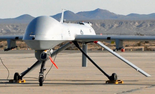
The 163d Reconnaissance Wing, California Air National Guard prepares the Predator MQ1 for lift off on it’s maiden voyage from Southern California Logistics Airport (SCLA) on 25 February 2009. (U.S. Air Force photo by Master Sergeant Stanley L. Thompson)
One thing is clear. We need to decide on a name. UAS, drone, RPV, or UAV.
****
(Originally published at 12:49 p.m. MDT, March 14, 2014)
These videos describe the use of a California Air National Guard Predator unmanned aerial system on the Rim Fire, which burned 257,000 acres in and near Yosemite National Park last summer.
HERE is a link to a 17-second video which can’t be embedded, but it shows the operator’s screen.
An A-20 UAS being launched by BLM personnel in Alaska. BLM photo.
The Federal Aviation Administration (FAA) and the Department of the Interior (DOI) have reached an agreement that will greatly simplify the operation of Unmanned Aircraft Systems (UAS) for certain uses. Previously the DOI and other agencies had to go through a lengthy and time-consuming FAA approval process before they could be used. Now there is much less paperwork and it appears that it can all be done within the DOI. This new process applies to aircraft weighing 55 lbs or less operating below 400 ft AGL and is limited to natural resource, scientific applications, and Search and Rescue efforts. Unfortunately, a UAS intended to be used for wildland fire still has to go through the tedious FAA approval process, after which the fire might be out.
Below is the information issued by the DOI Office of Aviation Services on January 23, 2014:
****
“United States Department of the Interior Office of Aviation Services Information Bulletin
Number: 14-03
Distribution: All DOI Employees
Subject: Issuance of the Memorandum of Agreement (MOA), dated Jan 23, 2014 between the Department of Interior (DOI) Office of Aviation Services (OAS) and the Federal Aviation Administration, UAS Integration Office (AFS-80) Regarding Operation of Small Unmanned Aircraft Systems in Class G Airspace.
Information:
This Information Bulletin (IB) identifies and clarifies DOI Bureau responsibilities in the implementation and use of this MOA.
This MOA establishes a framework under which DOI Bureaus must operate to comply with FAA rules and procedures pertaining to small UAS (sUAS) employment. The scope of sUAS operations under this MOA applies only to systems weighing 55 lbs or less engaged in public aircraft operations below 400 ft AGL and is limited to natural resource and scientific applications, as well as Search and Rescue (SAR) efforts. All other UAS operations to include wildland fire and law enforcement operations must still comply with the FAA Certificate of Authorization (COA) application and approval process before flights can commence. See attached flow chart for a graphical depiction of the project approval process for DOI UAS operations.
Victor Torres of Chang Industry holds a Sky Seer drone used by the Los Angeles County Sheriff Department. It may be similar to those purchased by the USFS. Photo by Xeni Jardin April 6, 2006.
The U.S. Forest Service spent $100,000 in 2007 to buy two Sky Seer drone aircraft that they have not figured out how to use. The story was reported at Environment & Energy and was featured at a web site about forest planning. Apparently the agency purchased the drones seven years ago initially to be used for law enforcement, but FAA regulations and other problems have presented obstacles to the very expensive unmanned aerial vehicles (UAV) taking to the skies.
The information came to light after the Public Employees for Environmental Responsibility filed a Freedom of Information Act Request which revealed a little about how the USFS may use the drones. In 2012 the agency created an Unmanned Aircraft Systems Advisory Group within their Fire and Aviation Management division which may indicate a desire to use them to gather intelligence over fires.
An article in the Missoulian published May 26, 2013 was titled “U.S. Forest Service drops plans to use drones in Montana, north Idaho”. The reporter was told the agency had no drones. Below is an excerpt:
MISSOULA — The U.S. Forest Service says it has no drone aircraft, but plenty of other people have little UFOs buzzing over the trees in Western Montana.
Last week, Forest Service officials said they’ve dropped plans to use unmanned aerial systems — commonly known as drones — to survey forest fires because of clashes with Federal Aviation Administration rules. While some national forest firefighters in Alaska touted the remote-control planes’ ability to map forest fires in thick smoke, their legality proved a limitation.
“Getting FAA approval to fly one is a lengthy process,” Forest Service Northern Region spokesman Phil Sammon said Friday. “It takes too long to make it practical for a two- or three-week occurrence.”
FAA rules require a drone in U.S. airspace to be in visual range of its pilot at all times. That sets up a Catch-22 problem where if you want to remote-control fly a drone into a smoke column too thick for human pilots to see through, you must still send up a human pilot to keep an eye on the drone.
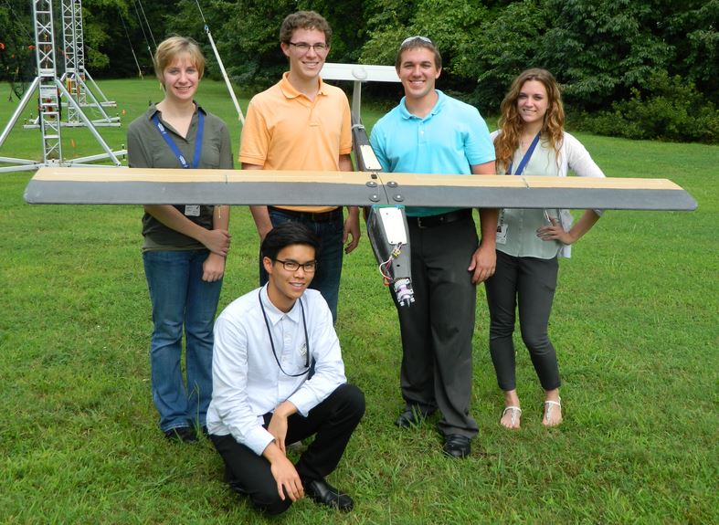
From left: Jennifer Hull, Steven Vo, Matthew Mannebach, Robert Harden and Coryn Mickelson with the fire-hunting UAV they designed and built over the summer at NASA’s Langley Research Center. Image courtesy of Mike Logan.
From NASA:
NASA Langley Student Team Designs Fire-Hunting UAV
Sept 26, 2013
You could say that the idea came to him in a cloud of smoke.
Over the summer, Mike Logan, an aerospace engineer at NASA’s Langley Research Center, put a group of students to work designing and building an Unmanned Aerial Vehicle (UAV) that could one day help to snuff out fires in Virginia’s Great Dismal Swamp.
The origins of the project go back to August of 2011. A lightning strike in the swamp sparked a blaze that ended up burning for four months. At one point, wind pushed the smoke as far north as Maryland. Logan, who lives due north of the swamp in South Hampton Roads, often found his house in the path of the acrid cloud.
“After choking down a few dozen clouds worth of peat bog smoke, which I found out I’m allergic to, I thought, you know, there really ought to be a better way,” he said.
So Logan made a phone call to the local fire captain. They had a couple of conversations and visited the swamp to do a sight survey. Logan learned that lightning causes the majority of the fires in the swamp, and that the only way swamp personnel are able to locate fire sources is to hire an outside contractor to do a manned aircraft survey.
It’s an expensive solution, and one that didn’t happen until nearly a week and a half after the 2011 fire started. By that time, the blaze had already spiraled out of control.
But that gave Logan an idea: why not develop a UAV that could fly over the swamp and detect fires before they get out of hand?
It was a simple solution to complex problem, and Logan tasked his student team with bringing it to fruition.
“I said, you know, this would be a perfect opportunity to give them some hands-on learning experience and oh, by the way, solve this massive problem pretty inexpensively,” he said.
The team, which included Aerospace Project interns Jennifer Hull, Robert Harden, Matthew Mannebach and Coryn Mickelson, and Langley Aerospace Research Student Scholars (LARSS) intern Steven Vo, had 10 weeks to design and build the UAV. Logan specified that it had to be low cost and operable by Great Dismal Swamp personnel. It also needed to be deployable within minutes or hours of a storm and able to autonomously detect, provide images of, and provide precise GPS coordinates for, small hotspots that might develop into serious fires.
“At first I was daunted,” said Hull, a recent University of Wisconsin-Madison graduate who didn’t have much experience building UAVs prior to tackling Logan’s project.
But Logan guided his team through the process, showing them how to cut foam parts for the UAV on a CNC hot wire machine. He also taught them to apply composite skins like Kevlar and fiberglass using a vacuum bagging system that molds and seals the composites to the body of the aircraft.
In addition, the students had to optimize the UAV’s airflow, install an auto navigation unit, test different motor-propeller combinations, and set up payloads (the aircraft had to carry a video camera and an infrared camera). They even manufactured a camera mount with a 3D printer and a heat sink that was cut using a water jet at NASA Langley’s fabrication shop.
“They learned all these things about how you fabricate stuff that they wouldn’t have gotten at the university,” Logan said.
Vo, a student at California Polytechnic State University, San Luis Obispo, certainly found it enlightening.
“I feel like this hands-on experience will help me become a better designer in the future as I will be able to better understand the feasibility of certain designs and where to compromise between design ideals and ease of manufacturing,” he said.
Toward the end of their 10 weeks, Logan’s team was ready to send its fire-hunting UAV up for a first test flight, but windy conditions thwarted one attempt and a last-second technical glitch stopped another.
Though the students have since left, Logan is hoping to make another attempt soon. Not only would this UAV potentially save the Great Dismal Swamp money, it could also save taxpayers money. Between the 2011 fire and another fire in 2008, taxpayers had to cover nearly $25 million in firefighting costs. That makes the idea of a UAV that could pinpoint hotspots and lead firefighters to them before they get out of hand that much more appealing.
Logan also sees commercial potential for the aircraft, and had the students design it with that in mind.
“The idea is to make this as easy to produce as possible,” he said. “And that was one of the items that I kind of stressed to the students is that hey, every time you have to perform an operation — what the people in the industry call touch labor — every step that you have to make, whether it’s turning a screw, whether it’s a vacuum bagging process or whatever, that costs money.”
Hull, who started the project daunted, but ended it “excited” and “confident,” said it was a great experience.
“There are many people out there who do not feel like they are contributing enough with their job and want to make a bigger and better impact on society, and this internship was amazing in that it let us do that,” she said. “If our UAV or a UAV inspired by ours is ever used by a park ranger in the Great Dismal Swamp and prevents just one wildfire, it will have my made summer.”