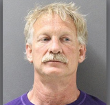
A man was arrested in Prescott, Arizona for flying a drone into the airspace near the Goodwin Fire that as of Friday had burned over 25,000 acres southeast of the city.
Gene Alan Carpenter, a 54-year-old from Prescott Valley, is accused of endangering 14 aircraft and ground personnel with a “substantial risk of imminent death or physical injury” by flying a drone near or over the fire. All firefighting aircraft had to be grounded for about an hour on Wednesday, June 28.
In 2016 Arizona passed a law making it illegal to fly a drone that interfered with emergency or law enforcement efforts. It is likely that a Temporary Flight Restriction was in effect over the fire at that time which would make it a violation of federal law for any aircraft to invade the space without permission.
If a drone collided with a firefighting helicopter or fixed wing aircraft it could cause great harm especially if it hit a windshield or engine. And if the aircraft crashes, killing the pilots, firefighters on the ground would also be in danger from the falling debris.
The safety of firefighters is compromised when all of the helicopters, lead planes, air attack, and air tankers are grounded, preventing the aircraft from slowing the fire so that firefighters can move in and construct fireline. When aircraft and ground personnel disengage, homes and private property could be destroyed that might otherwise have been saved with an aggressive firefighting attack. Some air tankers when grounded by an intruding aircraft can’t land with a full load of retardant, so they have to jettison it, wasting thousands of dollars worth of the product.
On June 24 multiple witnesses reported seeing a man operating a drone at the Goodwin Fire standing next to a white van.
Below is an excerpt from an article at 12news:
The sheriff’s office said based on witness information, drone descriptions and photos from Carpenter’s website showing drone views of the Goodwin Fire, deputies began searching for him.
Carpenter was arrested Friday afternoon after an off-duty deputy spotted his van on Willow Creek Road in Prescott. The drone was found in the van and seized.
Detectives are meeting with federal officials Monday to discuss additional charges based on the federal statutes regarding temporary flight restrictions.
Mr. Carter is in custody at Yavapai County facilities at Camp Verde, Arizona charged with 14 counts of endangerment, all felonies, and one misdemeanor.
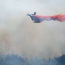
Three very large air tankers, DC-10’s that carry 11,600 gallons of fire retardant, assisted firefighters on the Goodwin Fire in Arizona Wednesday, reducing the fire’s intensity around endangered structures.
As of Thursday morning the fire had burned 24,828 acres at Mayer, Arizona.
The DC-10’s are often used on wildfires, but there are only three of the “Very Large Air Tankers” on contract with the federal government, and it is unusual for all of them to be working the same fire. They were reloading with retardant at Phoenix Mesa-Gateway airport 80 miles southeast of the fire.
Rick Hatton, President and CEO of 10 Tanker Air Carrier, said their three DC-10’s completed a total of 14 sorties to the Goodwin Fire during 16 total hours of flying Wednesday. He said the facilities and crews at the air tanker base accommodated the three huge aircraft very well.
Two of the aircraft are on exclusive use contracts with the U.S. Forest Service, and a third is on a call when needed contract.
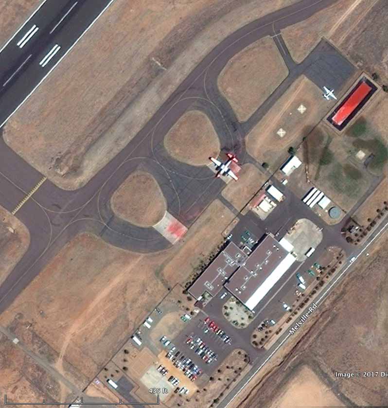
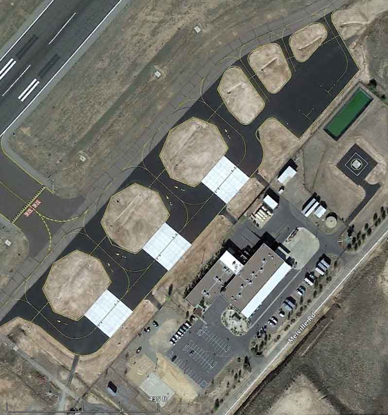
Even though $2.4 million was spent in 2014 to improve the apron and plumbing at the air tanker base at Prescott, 15 miles from the fire, it was not designed to handle Very Large Air Tankers. But it can accommodate the “large” or “heavy” air tankers, such as the aircraft that can carry 2,000 to 3,500 gallons, including the P2V, BAe-146, RJ85, MD-87, 737, and C-130.
To improve the tanker base, the City of Prescott agreed to accept a $1.44 million grant from the Arizona Department of Transportation (ADOT) which was combined with $1 million from the U.S. Forest Service. The USFS funds were used to add new plumbing infrastructure and a taxiway.
The changes increased the number of loading pits from two to three. The ADOT grant covered 90 percent of the cost of the apron project, and the City of Prescott supplied the additional 10 percent.
Below are photos of the Prescott air tanker base ramp before and after the modifications.
Air tanker base ramp at the Prescott Airport, June, 2010. Google Earth.Air tanker base ramp at the Prescott Airport, November, 2015. Google Earth.
As you can see below, Prescott makes a good temporary home for the helicopters working the Goodwin Fire.
An illegally operated drone flew into the fire area Wednesday, forcing all firefighting aircraft to be grounded for safety reasons. Law enforcement responded and is investigating the incident. Hobbyist drone operators are reminded that “if you fly, we can’t fly.” There is a Temporary Flight Restriction (TFR) over the fire area and it is against federal law to fly a drone within the restricted area. This also happened on the Brian Head Fire in Utah Wednesday, as well as the Lightner Fire in California.
In the video below you will see what appears to be a privately owned Blackhawk helicopter, a Firehawk, dropping retardant on the Goodwin Fire. Most of the time helicopters drop water directly on the flames, but the long term retardant can be effective when applied ahead of the fire.
This drone intrusion seriously compromised active helicopter operations at the Helibase and prevented an incident helicopter from returning from its mission until the intrusion was cleared.
Above: a P2V air tanker drops on the northern end of the Pinal Fire south of Globe, Arizona on May 24, 2017. Inciweb photo.
Drones operating illegally at the Pinal Fire south of Globe, Arizona have interfered with aviation operations four times since the fire started. One of those intrusions resulted in the drone being confiscated and the operator cited. Below is the text of a Rapid Lesson Sharing document about the incident, distributed by the Wildland Fire Lessons Learned Center.
****
“On May 20 at approximately 1805, an Unmanned Aerial Systems (UAS)—or drone—was spotted 60 yards from the Pinal Fire Helibase at approximately 50 feet above ground level.
The UAS was flying in the designated flight path of this incident’s helicopters where they were making their descents to land at the Pinal Fire Helibase, located within the city limits of Globe, Arizona. The UAS was white in color and approximately two feet in diameter.
Upon seeing the UAS, Helibase personnel contacted Helicopter 0TA, an incident helicopter that was flying a mission over the fire, to inform the pilot of the UAS intrusion into the Temporary Flight Restriction (TFR) and the hazard associated with the UAS being in the area.
The helicopter was asked to not come back to the Helibase until fire personnel were sure that the UAS was clear of the area. The Helibase Manager immediately called the Air Operations Branch Director (AOBD) to inform him of the UAS intrusion. The AOBD, in turn, contacted incident Law Enforcement—who responded immediately to the Helibase.
Helitack personnel were able to track the UAS while it was in flight. They were proactive in tracking the UAS and following its flight path. They observed the aircraft descend and land at a nearby residence in the vicinity of the Pinal Fire Incident Command Post.
UAS (Drone) Operator Located and Cited
The LEO arrived at the Helibase. He was informed of the location where the UAS descended and landed. The LEO had enough information to go make contact with the UAS operator and was able to confiscate the UAS and cite the individual.
This UAS intrusion within the TFR posed a serious safety concern for incident pilots and fire personnel involved in helicopter aviation missions on the Pinal Fire. The UAS intrusion impeded the operations of the Helibase and—should a collision occur—posed a serious hazard.
Quick and decisive action by the Pinal Fire Helibase Manager, incident Helibase Crewmembers, and local Law Enforcement personnel brought this intrusion incident to a quick and decisive resolution.
LESSONS
Establish appropriate TFRs early in the incident and ensure that the incident Helibase is included in the polygon.
All fire personnel should stay alert to the possibility of UAS intrusions, particularly when operations are in or near an urban setting.
If a UAS is sighted within a fire’s theater of operations, ensure that the intrusion is communicated to all incident personnel.
If a UAS intrusion should occur, ensure that incident personnel are diligent and persistent in documenting information relative to the intrusion, including: UAS description, direction of flight, and—if possible—determining the originating location of the UAS for LEO follow-up.
Provide UAS cautionary messaging as part of the incident narrative summary in INCIWEB.”
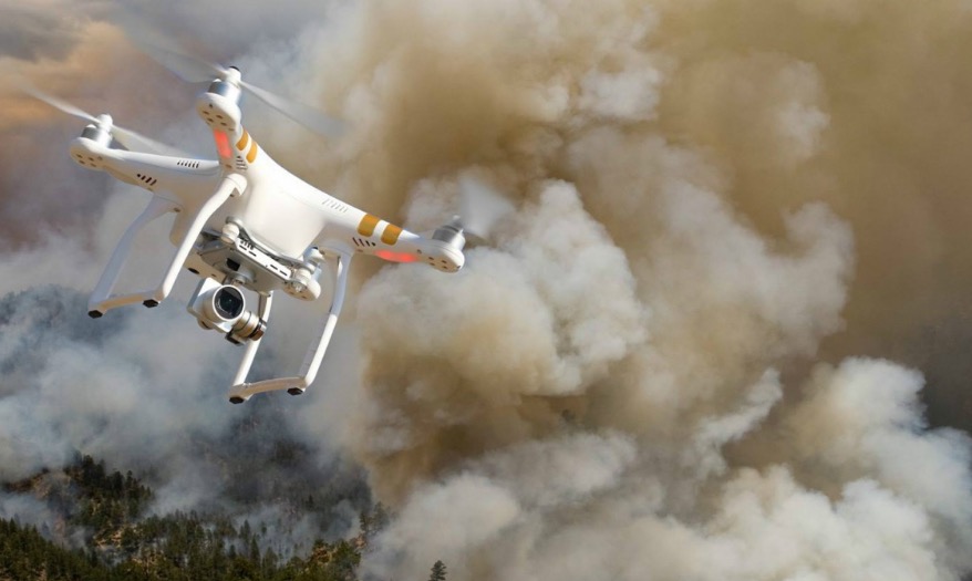
A drone flying over a wildfire. Photo by the Bureau of Land Management.
By Ryan Maye Handy and Bill Gabbert
Since 2014 instances of drones shutting down air operations over wildfires has increased despite repeated warnings to the public.
While there is no formal system to track the number of times Unmanned Aircraft Systems, or drones, have invaded the airspace over wildfires, the U.S. Forest Service has managed to collect some numbers thanks to public reports. And the numbers seem to show that warnings to not fly drones over wildfires often go unheeded.
“In spite of increased and ongoing public education from the interagency fire community and incident management teams by way of the internet, social media, press conferences, news release, etc., about the risks and hazards hobby drone operators present to aerial firefighting aircraft, the public continues flying hobby drones near or over wildfires,” said Mike Ferris, a public information officer with the Forest Service.
Earlier this summer, following a spate of issues with drones flying over California wildfires, the National Interagency Fire Center issued a statement cautioning drone pilots that they could face criminal charges if caught flying drones over a fire. Then in July, CALFire made its first arrest of a drone operator, who now faces a misdemeanor charge in connection to flying the drone over a California wildfire. Ferris did not know about criminal charges against other drone pilots in connection to wildfires.
Forest Service officials say that the small aircraft pose a tremendous threat to the low-flying planes that work above firefighters. A collision of a drone and an airtanker, for instance, could be disastrous, Ferris said.
“Aerial firefighting aircraft, such as air tankers and helicopters, fly at very low altitudes, the same as UAS flown by the general public, creating the potential for mid-air collision that could be fatal for aviation and/or ground firefighters, as well as members of the public,” he said.
Nonetheless, problems have persisted. In the past two months, drones flying too close to wildfires grounded planes in New Mexico, Arizona, Minnesota, Alaska, Utah, Montana and California. This year, there have been 34 instances of drones encroaching on firefighting airspace, and 12 times planes were grounded, according to the Forest Service.According to the June Wildfire Airspace Situations report, aircraft on three fires in Utah were grounded the span of two days in July due to drone activity.
Those numbers are up slightly from 2015, when drones were spotted near wildfires 21 times in five states–California, Colorado, Oregon, Utah, and Washington, Ferris said.
“This resulted in aerial firefighting operations being temporarily shut down on at least ten occasions, which may have caused wildfires to grow larger and unduly threaten lives, property, and valuable natural and cultural resources,” Ferris said.
This summer, when nearby drones forced the shutdown of air operations in Montana and California, aircraft were grounded for 30 to 45 minutes. Although drones briefly shut down air operations over the Soberanes fire in Northern California, the upset came at a crucial time—just days after the massive fire exploded and was burning with little to no containment. The fire’s incident management team has made anti-drone warnings a permanent fixture on its InciWeb site, where it posts all updates on the fire.
One of the largest manufacturers of drones, DJI, has incorporated a geofencing feature into their drone control software that prevents flying into locations where they don’t belong. The system was recently upgraded to keep the pilotless aircraft away from airports, prohibited and restricted airspace, national security sites, prisons, and power plants, among other locations. Additionally, when a user is connected to the internet, the software will provide live guidance on Temporary Flight Restrictions (TFRs) including those relating to forest fires, major league sporting events, and other changing conditions.
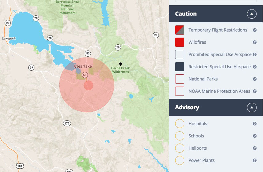
The Department of Interior has implemented a prototype of a system, some might call it a beta version, that provides data allowing the drone manufacturers to add another layer of geofencing. It provides near real time information about the location of wildfires, using data collected by the Integrated Reporting of Wildland-Fire Information (IRWIN) service. During the prototype year, the data is supplied to two volunteer, commercial mapping providers that support drone operations, AirMap and Skyward. It is available on the web and as an IOS app (Airmap) that allows anyone to use the information to avoid wildfires. The fire location data is available online and in the app as soon as the local dispatcher loads the fire location data into the system. It appears on the maps as a 2-mile radius circle along with TFRs.
A screenshot from the Airmap website showing the area of the Clayton Fire at Lower Lake, California August 15, 2016. The small red circle is the 2-mile radius that appears as soon as the dispatcher enters the location. The larger circle is the TFR.
As long as the DJI drone operator is connected to the internet, the system will warn the operator not to fly into the area, even before a TFR is established. However at this stage, during the prototype or beta period, it will only be a warning and can be ignored. DJI and other drone companies could change that next year, making it impossible to fly into a fire area.
It is hoped that other drone manufacturers, in addition to DJI, will begin to use the real time geofencing data available from the Department of the Interior. But, a weak link in the system is that the drone operator must be connected to the internet to obtain the near real time updates for wildfire location information. Many wildfires occur in remote settings without internet access; however, responsible pilots, whether flying manned or unmanned aircraft, will do pre-flight planning to identify potential hazards along the route prior to their flight. Drone operators are reminded if you see smoke in the vicinity, leave your drone at home. Because, if you fly, firefighting aircraft can’t.
Meanwhile, it seems that the public’s fascination with drone technology drives them to keep flying drones over wildfires. A quick search on Youtube.com turns up many cautionary clips warning drone operators to stay away from wildfires—but there are just as many clips of wildfire footage captured by drones.
The drone forced the grounding of firefighting aircraft.
Officers with the California Department of Forestry and Fire Protection arrested a Placer County man Friday who allegedly interfered with firefighting operations recently on the Trailhead Fire by flying a drone over the fire, forcing fire managers to ground aircraft rather than risk a collision.
Information posted on social media helped lead law enforcement officers to Eric Wamser, 57, of Foresthill. He was arrested Friday afternoon, booked into the Placer County jail in Auburn and charged with interfering with firefighting operations. This is the first arrest by CAL FIRE law enforcement of a drone operator for interfering with firefighting.
Chief of CAL FIRE Ken Pimlott sent out a Tweet Friday night saying, “We will seek to prosecute those who put the public and our firefighters in peril with irresponsible use of drones.”
Mr. Wamser’s alleged actions delayed aerial firefighting on a fire burning in the steep canyon along the Middle Fork of the American River near Todd Valley. The Trailhead Fire started June 28 and is now 98 percent contained, according to CAL FIRE. It burned more than 5,600 acres and forced hundreds of residents of Placer and El Dorado counties to evacuate.
“The Trailhead Fire was burning in such a remote area that our aircraft were critical to stopping the fire,” said Chief George Morris III, CAL FIRE’s Nevada-Yuba-Placer unit chief. “Every minute we couldn’t fly our aircraft because of this drone, the fire was able to grow and do more damage.”
Lawmakers in Utah have passed a bill that would allow authorities to disable drones that are flying close to wildfires. While the legislation would allow the aircraft to be shot down, it is more likely that they would be disabled by electronic devices that would jam the radio signal or force them to land. Violators could be fined up to $15,000 or be sentenced to 15 years in prison.
Below is an excerpt from an article at the Star Tribune:
…Bill sponsor Sen. Evan Vickers told The Associated Press that the state highway patrol and National Guard already have the technology.
“The redneck in me is just to shoot the damn thing,” Vickers told lawmakers, adding that it was much more “humane” to jam the drone’s signal.
He said the technology allows officials to target a specific drone and can be used without hurting other nearby aircraft or technology.
[Senator Vickers said] before the vote that the costs of fighting a small wildfire burning about 300 miles south of Salt Lake City would have been several million dollars if five drone flights hadn’t interfered.
“Now we’re way past, north of $10 million because we had to ground aircraft all because of a drone,” Herbert said.
The Washington County Sheriff’s Office has been investigating drones flying near the fire, which is burning on a rocky ridge above the town of Pine Valley, but no arrests have been made or suspects identified. The sheriff’s office has offered a $1,000 reward for information that leads to an arrest…
Leaders of the House Transportation and Infrastructure Committee and the Senate Commerce, Science, and Transportation Committee today announced they have reached a bipartisan agreement on a Federal Aviation Administration (FAA) extension through September 30, 2017, that will affect the U.S. aviation system, including the use of unmanned aircraft, or unmanned aircraft systems (UAS), over wildfires.
Much of the agreement is directed toward airports and passenger screening, but four sections will be of interest to wildfire agencies.
The proposed legislation will require that the FAA convene industry stakeholders to facilitate the development of consensus standards for remotely identifying operators and owners of unmanned aircraft systems and associated unmanned aircraft. This is the first time I have heard of this idea. If implemented, when a UAS interferes with firefighting aircraft the operator could be identified, making it possible to slap them with a fine of up to $20,000, which is another provision in the agreement.
In addition, the proposed legislation requires the development of technologies to mitigate threats posed by errant or hostile unmanned aircraft systems. This could make it possible to disable a UAS that is interfering with aircraft operations over a wildfire.
The FAA is also directed to enter into agreements with the Secretary of the Interior and the Secretary of Agriculture, as necessary, to continue the expeditious authorization of safe unmanned aircraft system operations in support of firefighting operations.
The leaders of the House and Senate said they hope to get the passed legislation to the president before the July 15 expiration of the FAA’s current authorization.
Several times in the last 10 days drones flying near wildfires have required that firefighting aircraft cease operations, sometimes for hours at a time.
Yesterday the Federal Aviation Administration sent a mass email to individuals who have registered their drones with the agency, warning them that “drone operators who interfere with wildfire suppression efforts are subject to civil penalties of up to $27,500 and possible criminal prosecution”.